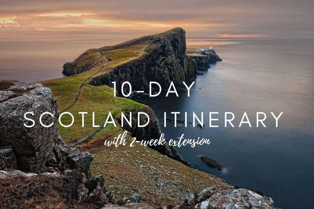
10-Day Scotland Itinerary (with 2-week extension)
Not every country of Scotland’s size (read: small) can keep you occupied for this long without considering eating lunch and dinner a proper item on the itinerary. Scotland on the other hand? You’ll be lucky if you have time for food! Spending 10 action-packed days in Scotland is a breeze.
I’m going to say it right now in case you’re wondering how long you should spend in Scotland—if you can, add extra days on. For you, I’ll post an extended itinerary below. It adds a few days on for a total of 2 weeks in Scotland.
Are you on the other side of the vacation time spectrum and only have 1 week? I’ll point you in the direction of my 7-Day Scottish Highlands Road Trip Itinerary. You’ll have to tweak it ever so slightly so at least one of those days is re-delegated onto Edinburg, because missing Scotland’s capital would be a big no-no.
Make sure to read our FAQs at the end of this article to make double sure you have the appropriate gear for this trip (I can’t stress this point enough) and know what weather to expect.
Itinerary overview
Before you dive into the detailed plans, let’s take a look at the basics of this itinerary.
How this itinerary works
A few things you should know about this itinerary:
- For each day, I include a map, recommended restaurants and hotels, driving distances and the total time that you’ll need for all the activities (including driving times).
- This is a road trip. You’ll be changing hotels at least every couple of days so you can really experience what each part of Scotland has to offer.
- There are no rest days. If you want to have a more chill vacation, add more days without adding more stops.
- I recommend reading my article about driving in Scotland for the first time to get an idea of what to expect on Scottish roads. In a nutshell, it ain’t hard, but it sure as heck ain’t fast, either. And it’s on the left.
- I’ve used my 2-day Isle of Skye itinerary and the 7-day Highlands road trip itinerary as a basis for this itinerary. You can go look at those for extra stops, but the highlights of them are already included here in the same detail.
You might also be interested in reading:
- Isle of Skye Itinerary for 2 days
- 13 Best Places to Visit in Scotland for Couples
- 32 Fun Facts About Scotland: From Uniting the Kingdom to Unicorns
- Driving in Scotland: Itineraries for the 7 Best Road Trips + Tips
Itinerary map

Day-by-day trip plan
For the 10-day version of this Scotland itinerary, here’s a brief schedule of the individual days:
Day 0: Arrival to Edinburgh, drive up north (sleep in Ullapool)
Day 1: Assynt (sleep in Ullapool)
Day 2: Assynt (sleep in Ullapool)
Day 3: Northern Highlands (sleep on Isle of Skye)
Day 4: Northern Isle of Skye (sleep on Isle of Skye)
Day 5: Southern Isle of Skye (sleep in Glencoe)
Day 6: Glencoe (sleep in Glencoe)
Day 7: Glencoe (sleep in Trossachs)
Day 8: Trossachs National Park (sleep in Trossachs)
Day 9: Stirling (sleep in Edinburgh)
Day 10: Edinburgh (sleep in Edinburgh)
The 2-week variant of this itinerary adds on Cairngorms National Park and gives you an extra day in Trossachs National Park, Glencoe and Edinburgh:
Day 0: Arrival to Edinburgh, Blair Castle (sleep near Blair Castle)
Day 1: Cairngorms National Park (sleep in Ullapool)
Day 2: Assynt (sleep in Ullapool)
Day 3: Assynt (sleep in Ullapool)
Day 4: Northern Highlands (sleep on Isle of Skye)
Day 5: Northern Isle of Skye (sleep on Isle of Skye)
Day 6: Southern Isle of Skye (sleep in Glencoe)
Day 7: Glencoe (sleep in Glencoe)
Day 8: Glencoe (sleep in Glencoe)
Day 9: Glencoe (sleep in Trossachs)
Day 10: Trossachs National Park (sleep in Trossachs)
Day 11: Trossachs National Park (sleep in Trossachs)
Day 12: Stirling (sleep in Edinburgh)
Day 13: Edinburgh (sleep in Edinburgh)
Day 14: Edinburgh (not sure where you’ll sleep)
Further reading:
Day 0: Arriving in Scotland and driving to Scottish Highlands
More likely than not, you’ll be flying into Edinburgh when traveling to Scotland.
If you want to get to the city center from the airport without a car, you can take a taxi, the Airlink Express Bus, or a tram. They all take approximately 30 minutes.
For this itinerary though, we’re leaving Edinburgh for the end of the trip, and we aren’t taking public transportation, so you’ll be renting a car right upon arrival at the airport. We highly recommend a Scottish company, Arnold Clark (no affiliation, we were just super happy with their services).
To get to Arnold Clark, there’s a 5-minute shuttle from the Edinburgh airport that’ll take you to their office. Their prices are comparable to others and the cars are very good.
Drive to Ullapool (with optional castle stop)

Today’s main objective is to get to Ullapool in the Northern Highlands, where the real fun starts tomorrow. It’s about a 4-hour drive from Edinburgh.
Depending on when you arrive to Scotland, you may or may not have enough time to break up the long drive at Blair Castle.
Blair Castle is 1.5 hours into the drive and a full tour would take 3 hours. If you have that kind of time, great, if not, skip the castle interior and just gaze at it from the amazing gardens. I preferred those to the tour of the rooms, though it is self-guided, so you could blaze through if you wished.
The castle restaurant appears to have some lovely meals, and though I can’t vouch for them from personal experience, just note it’s there, because you’re bound to be hungry after your flight!
Get the full details on a Blair Castle visit in my Best Castles in Scotland article.
Tip if you arrive late: If you fly into Edinburgh late and aren’t up for the long drive, I’d at least drive up to Blair Castle and sleep there so you can continue from there bright and early in the morning. It’s possible to book a stay at some of the lodges and cottages on the castle grounds, but you’re looking for something a bit more hotel-y, stay 10 km (6 miles) away in Pitlochry, which has a wider selection of accommodation.
- Blair Castle & Gardens website
- Google Maps link (this will take you to the main gate)
- Open daily 10 am–5 pm in April to September. Otherwise closed.
- Tickets cost GBP 16 for castle+gardens, GBP 8 for just the gardens.
Your goal is to reach your accommodation in or around Ullapool before nightfall.

The hotels I recommend are Aultguish Inn in Garve (30 minutes south of Ullapool, so you’ll get there faster) and Harbour House in Ullapool.
We stayed at Aultguish Inn, and while it was further away from Ullapool, I slept so well there I can’t stop dreaming about it.
Harbour House is in an awesome location right on the water and right in Ullapool, so I wouldn’t hesitate staying there next time, either.
They are both similarly priced at around GBP 150 (USD 170) for two people with breakfast.
Just so you know, we get a small commission whenever you book a hotel through one of our affiliate links. You pay nothing extra. Thank you for showing the love, we really appreciate it!
Day 1: Assynt, Northern Highlands

Total driving distance: 56 km (35 miles) with a start and end in Ullapool
Time needed: 6–7 hours plus food stops
Stops on day 1: Stac Pollaidh, Knockan Crag Geopark
Restaurant tip: Seafood Shack in Ullapool
Hotel recommendations: Aultguish Inn in Garve | Harbour House in Ullapool
Further reading: Best hikes in Scotland | Best of Northern Highlands | Scottish Food Guide
Day 1, 1st stop: Stac Pollaidh hike

Distance from Ullapool: 30 minutes/24 km/15 miles
Time spent here: 3–4 hours (or 2.5 hours for the circuit)
Starting point: Stac Pollaidh parking lot
Hike length: 7 km/4.3 miles (or 4.5 km/2.7 miles if doing the circuit)
Difficulty level: Hard (quite steep and muddy)
The Stac Pollaidh hike is our no. 1 best hike in Scotland and even topped our list of the best places to see in Scotland. Don’t even think about skipping this experience!
It’s quite steep and hard, because of the rain and muddy paths (especially in the western section). It’s the first time you’ll put your gear to the test (again, please read the FAQs at the end of this article).
You will also gain about 450 m (1470 ft) elevation on the circuit, or you can summit and add another 150 m (490 ft)—but be ready to scramble!
The standard direction to hike the trail is a counter-clockwise circuit around the summit, but I would definitely go clockwise and make it out-and-back. You would walk about ¾ of the path and then turn back. The path will is better and has the best views. This way you avoid the muddiest/marshiest part of the trail (the western part).

This is the place where you’re going to see those little lochs and green mountains and will feel proper Scottish weather—we visited in July and it was super windy and snowing. Gear up!
The hike starts at the Stac Pollaidh parking lot—a 20 minute drive from Ullapool.
Day 1, 2nd stop: Knockan Crag Geopark

Distance from last stop: 15 minutes/13 km/8 miles
Time spent here: 2 hours
Starting point: Knockan Crag parking
Knockan Crag is the place where it was discovered that Scotland was originally not anywhere close to being a part of England, only floating together a relatively short time ago (in Earth years). Due to the unique geology you can actually see the crag where two tectonic plates meet.
It’s also where you can see the oldest rocks on Earth—4 billion years! Or, if you think God created the Earth, then a whopping 6,000 years!
Don’t just stare at the rocks though and look around once in a while—you’ll be getting fantastic views of Assynt.
Parking, toilets and a small coffee shop are all located in one place, and the trail starts right there as well. The geopark is all outside, so don’t think you’ll be hiding from the elements.
First, visit the open-air interpretation center—the Rock Room—and then take the trail up above the crags to get amazing views. There are 3 walks to choose from depending on fitness level and length. We did the longest one, which is roughly 2 km (1.2 miles) long.
There’s an audio guide available on the Knockan Crag official website in case you want to just pump your brain with info while walking around.
There’s no entrance fee. It will take you about 2 hours to explore the center and the educational trail which is immensely interesting and probably the best educational trail I’ve seen in my entire life.
People of any fitness level can visit Knockan Crag, just don’t underestimate the weather. When we started the hike it was blue skies. The temperature dropped by like 15°C in 20 minutes and it started to snow. Wind was crazy as well. I thought I’d freeze by the end of it, wearing just a t-shirt.
Day 2: More Assynt!

Total driving distance: 130 km (80 miles) with a start and end in Ullapool
Time needed: 10 hours plus food stops
Stops on day 2: Suilven hike, Achmelvich Beach
Restaurant tip: Peet’s Lochinver by Suilven trail start, Fish & Chips Shop at Achmelvich
Hotel recommendations: Aultguish Inn in Garve | Harbour House in Ullapool
Further reading: Fun Facts About Scotland | Best of Northern Highlands | Scotland For Couples
Tip: The road you’ll be driving on today is the Lochinver to Ullapool scenic drive. It’s a destination in its own right, so keep your eyes peeled and take in the beauty. There is no boring driving in Scotland!
Day 2, 1st stop: Suilven hike

Distance from Ullapool: 1 hour/60 km/37 miles
Time spent here: 6–7 hours
Parking: On the road 800 m (0.5 miles) before reaching Glencanisp Lodge (map link)
Starting point: Glencanisp Lodge
Hike length: 20 km (12.5 miles) out and back
Difficulty level: Hard
You’ll feel like it’s the end of the world at Suilven! At least this is how I imagine it. Mostly bare and rugged.
This hike is 20 km (12.5 miles) of lots of amazing views and takes 6–7 hours round trip. I probably liked the first part of the trail the most, because you see some really pretty lochs with those cute miniature islands in them that are full of lush vegetation and trees in an otherwise bare place.
Taking that into consideration, if you think the hike is too long for you, you can turn back at any time after you’ve enough views. They are a bit repetitive anyway.
Tip: If you shortened the Suilven hike and need more things to fill your day with, read about Loch Assynt, Ardvreck Castle, some really old tombs, and the Bone Caves in my article about Scotland’s best scenic drives. They are all easy stops on today’s route. There’s also an optional hike on the next stop of the itinerary, so mix and match to suit your preference.
On the hike you’ll see rocks that are 500 million to 3 billion years old, so it’s a pretty darn cool hike.
Beware the final section up to the summit is steep and you need to be ready to scramble. I think you can still enjoy the Suilven hiking trail even if you decide not to go all the way to the top of the mountain.

You can leave your car at the small parking area on the road about 800 m (0.5 miles) before reaching Glencanisp Lodge, which is where the trail starts.
Once again, a friendly reminder to be ready for rain and possibly snow and wear waterproof everything. And layers.
If you’re hungry after the hike (how would you not be?!), check out Peet’s Lochinver in the town closest to the Suilven trail start or wait until you reach the next stop and grab a bite at Fish & Chips Shop right by the beach.
Day 2, 2nd stop: Achmelvich Beach

Distance from last stop: 20 minutes/8 km/5 miles
Time spent here: 1 hour (more if hiking)
Parking: Achmelvich Beach parking lot
Achmelvich is a very nice, tropical-like beach in Assynt, just a 20-minute drive from the Suilven hike parking area.
There’s an optional 5 km hike in the area around the beach that includes views and a hermit’s castle (that’ll take you about 2 hours to complete), OR, you can skip the walking and go straight to beaching, since the parking lot is right there.
At the parking lot, use the parking machine to pay (by card). It’s GBP 1 per hour.
Achmelvich is a very pretty and cold beach. Locals swim there even if it’s 18 °C outside, but you can just relax after your Suilven hike or walk on parts of the trail if you opted out of Suilven.
Day 3: Between Assynt and the Isle of Skye

Total driving distance: 175 km (108 miles), start in Ullapool, end in Portree
Time needed: 10 hours plus food stops
Stops on day 3: Falls of Measach, Beinn Eighe hike, Bealach na Ba scenic road
Restaurant tip: Applecross Inn in Applecross |
Hotel recommendations: Cuillin Hills Hotel in Portree | Greshornish House Hotel in Edinbane
Further reading: Driving in Scotland | Best Places to Visit in Scotland | About Scotland
Today you’ll be driving down from Ullapool to the Isle of Skye and changing hotels. But before you explore it there, there’s still a lot to see on the mainland! This is in no way an unnecessary driving day.
Day 3, 1st stop: Falls of Measach and Corrieshalloch Gorge

Distance from Ullapool: 20 minutes/20 km/12 miles
Time spent here: 1 hour
Parking and starting point: Parking lot on road A832
The Falls of Measach are located in the Corrieshalloch Gorge, very easy to find and access, and very easy to fall in love with. They’re a 20-minute drive south from Ullapool.
There’s parking on A832, use the QR code on the donation box to pay for it. The trails to view the waterfalls start right from there.
It’s a very good path that should be easy enough for everyone to take (very slight elevation gain), plus if you just want to get to the bridge, take a look and go back, you can be done in 30 minutes or so. Depends how much of a hurry you’re in to get to Beinn Eighe.
But when you do get to the bridge…wow, it’s a very dramatic drop of about 70 m (230 ft), with a limited number of people that can be on the bridge at any given time. And there, in the middle of the gorge, is the spectacular waterfall!
After the bridge, you can (and should!) keep going to another viewing platform, sort of hanging in the middle of the gorge. It’s awesome, a little scary for the faint of heart, but I definitely recommend it.
You can go back to your car the same way or take another path that’ll make your trip slightly longer.
Day 3, 2nd stop: Beinn Eighe hike

Distance from last stop: 1 hour/75 km/47 miles
Time spent here: 3–4 hours
Starting point: Beinn Eighe National Nature Reserve Car Park
Hike length: 5.5 km (3.5 miles) circular
Difficulty level: Hard
The start of this hike is about an hour’s drive from the Measach Falls parking lot.
The Beinn Eighe circular hike has the best signposting on any hike I ever did in the UK. There’s a proper hiking path (that starts right by the parking lot) with good signs and directions, and it’s rock solid (not sliding or disappearing into the mud as is standard in other places).
The great paths ensure you don’t need to worry as much about the weather, because you’ll be able to walk the trail no matter what’s falling from the sky. But be ready for almost 600 m (2000 ft) elevation gain over 5.5 km (3.5 miles).

These are the Scottish Highlands! Lochs everywhere and lush green vegetation that for some reason reminded me of the Araucaria forests in Huerquehue NP in Chile.
Because of rain and fog (and so many frogs and deer!), it’s a place of great imagination. Sometimes it was so foggy that we could let our imagination run loose, because you literally couldn’t see what was hiding in it—there could be a loch, the sea or maybe Mount Everest—who knows!
Day 3, 3rd stop: Bealach na Ba mountain pass

Distance from last stop: 1 hour/45 km/27 miles
Time spent here: 1.5 hours driving plus extra time to eat in Applecross
Starting point: Tornapress
End point: Applecross
Distance on scenic road: 18 km (11 miles)
Bealach na Ba (the Pass of the Cattle) is an 18 km (11 miles) scenic road through the mountains between Tornapress and Applecross. It’s one of the best drives in Scotland, I absolutely loved it.
Realistically, one way takes about 30 minutes, but I bet you’ll take at least an hour getting there just because of all the stops you’ll be making in order to take in those views. You’ll be faster on the way back (same route).
It’s single-lane in some places, so take your time. There are a lot of winding parts, especially in the beginning, but we always felt safe.
Make sure to take photos in the first third of Bealach na Ba, because this is where you’ll get the best views down to Lock Kishorn.

There are also a few hikes along the way, which might be worth it to extend your enjoyment of the fantastic scenery. I’m guessing that after Beinn Eighe, you’ll probably skip those. Plus, there’s still a lot of driving ahead!
The end of the road is in Applecross with the famous fish bistro Applecross Inn with fish ice cream, homemade beer and some of the best seafood in England. Be sure to make reservations as this place gets crowded in top tourist season.
If you’re lucky, you’ll see dolphins playing near the shore in Applecross! We did.
Day 3, 4th “stop”: Drive to the Isle of Skye

Driving distance: 2 hours/120 km/75 miles from Applecross to Portree
Once you are done in Applecross, you drive back to Tornapress the same way and then continue on to the Isle of Skye, which is where your road trip in the Scottish Highlands continues tomorrow.
The drive is a long one, 120 km (75 miles), and will take about 2 hours. Remember this is a road trip, so enjoy! Again, there is no bad scenery in Scotland. And at least you’re safe from the elements in your vehicle.
Where to stay on Isle of Sky (for days 3 and 4)?

You’ll be spending the following two days and two nights on the magnificent Isle of Skye.
The itinerary will be split up into a day for the north and a day for the south, so I think the best base is somewhat in the middle in Portree. There’s also a wonderful hotel closer to Dunvegan Castle, but the location of it will mean more driving.
Hotel note: We make a small commission if you use our affiliate link to book any hotel, not just the ones mentioned here—a big thank you if you do!
The 4-star Cuillin Hills Hotel has views over Portree Bay and the mountains in the background, and has a great restaurant where you can taste the award-winning whiskies.
Rooms are spacious and traditionally decorated with a modern touch and have large windows.
Prices from GBP 170 (USD 190) per night including breakfast.
Greshornish House Hotel is another 4-star, located a 25-minute drive to the west of Portree, near Dunvegan Castle. It’s a classic Scottish house with garden and lake views.
There’s a welcoming sitting area with a fireplace for those chilly evenings, and a wonderful breakfast room and outdoor sitting area, too.
Prices from GBP 130 (USD 150) per night including breakfast.
Day 4: North of Isle of Skye

Total driving distance: 165 km (102 miles), start and end in Portree
Time needed: 12 hours plus food stops, you can save 2.5 hours if you skip the optional stops
Stops on day 4: Old Man of Storr, Lealt Falls, Brother’s Point, Kilt Rock, An Corran Beach, Quiraing Walk, Fairy Glen, Dunvegan Castle gardens, Coral Beach, Neist Point Lighthouse
Restaurant tip: Scorrybreac Restaurant in Portree | The Galley Café near Fairy Glen
Hotel recommendations: Cuillin Hills Hotel in Portree | Greshornish House Hotel in Edinbane
Further reading: Food of Scotland | Best Places on Isle of Skye | Fun Facts About Scotland
You will be starting and ending the day at your hotel in the northern part of Isle of Skye, and it’s going to be a long day!
Today you’ll be driving on one of the most beautiful scenic roads in Scotland, the A855. The road itself is only 55 km (33 miles) long, but it’ll it’s where Isle of Skye’s highlights lie, so it’ll take you hours to get through it.

After driving around the highlight-packed northeastern corner of the Isle of Skye you’ll head out to the westernmost point of the island and end your day with a spectacular sunset at a lighthouse.
You can skip over some stops if you aren’t up for such a packed day. I’ve marked a couple of places as optional in case you can’t decide what to leave out.
Be prepared for driving on a sometimes single-lane road, meaning you’ll need to be patient and stop and let cars pass from time to time, as well as squeeze past others that stop for you.
Day 4, 1st stop: Old Man of Storr

Distance from Portree: 15 minutes/11 km/7 miles
Time spent here: 2 hours
Parking and starting point: Old Man of Storr Parking Lot
The first place of touristic interest you’ll pass on the way up A855 from Portree is Bride’s Veil Falls, but they are really small and you don’t have time to waste, so I say skip them.
Instead, hightail it to one of the highlights of Isle of Skye, the Old Man of Storr walk. One of the famous Skye walks full of classic Scottish views of green mountains, lochs and rugged rocks. And a giant’s thumb protruding from the ground.
The Old Man of Storr walk takes about 2 hours to complete. It’s a 4.7 km (3 mile) circular hike with around 350 m (1100 ft) elevation gain.

Google Maps does a great job showing the parking lot and the trailhead, which are right next to each other.
Parking costs GBP 3 for 3 hours. If the parking lot is full by the time you get there, you can park on the side of the road closest to it. Don’t worry, you’ll see what I mean and certainly won’t be the only one.
Details about this hike in our article about the best hikes on the Isle of Skye.
Day 4, 2nd stop: Lealt Falls

Distance from last stop: 8 mins/8 km/5 miles
Time spent here: 2 hours
Parking: Lealt Falls Parking Lot
Lealt Falls is only a 10–15-minute stop, but it’s a must-see for the views (not so much for the falls).
It takes no effort as the viewing platform is just a few steps away from the tiny parking lot (which is free). The waterfall is nice, but nothing that special. The view overall is way better.
There’s also a little side trail that you can walk on for a few minutes to get wonderful views of the coast.
Day 4, 3rd stop: Brother’s Point

Distance from last stop: 3 mins/2.5 km/1.5 miles
Time spent here: 20 minutes
Parking: Brother’s Point Parking Lot
Just a couple minutes from Lealt Falls is another quick stop called Brother’s Point. It’s a viewpoint with views out to the sea that you can see in 20 minutes max.
It’s special because somehow a lot of people skip it, so it’s one of the only places on your Isle of Skye itinerary that you might even end up being alone, bar the sheep (and large amounts of sheep shit).
Look for the sign right off the parking lot (free) and follow the (sometimes hard to see) trail. It’s only a short walk to the viewpoint.
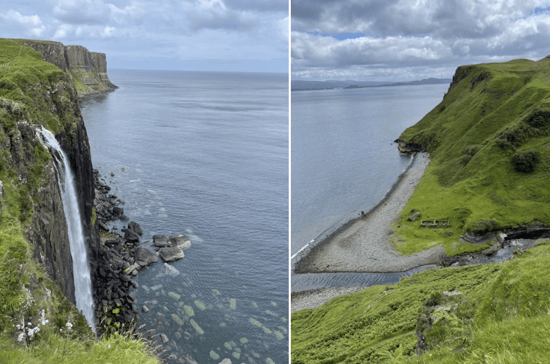
Day 4, 4th stop: Kilt Rock
Distance from last stop: 3 mins/3 km/2 miles
Time spent here: 10 minutes
Parking: By the Black Sheep food truck
Kilt Rock is a 10-minute stop. It’s an observation point where you can see the basalt columns over the sea and waterfalls, also over the sea. The parking lot is about 2 steps away from the viewpoint, which makes it a super easy stop.
Google Maps doesn’t show the parking lot, but it does show the food truck that is stationed on the parking lot, so head towards that. You might need to wait for a spot.
You’d think these views would be getting old by now, but no. Still spectacular. Also, you might be lucky and see a whale or two!
Hungry? You’ll probably be ready for a bite at this point, which is perfect timing, because The Black Sheep Food Truck at the parking area is where you can buy some great snacks. You can eat in the car or take your snacks to the next stop, An Corran Beach.
Day 4, 5th stop: An Corran Beach (dinosaur footprints)

Distance from last stop: 5 mins/5.5 km/3.5 miles
Time spent here: 15 minutes
Parking: Staffin Harbour Car Park
An Corran is a beach whose main claim to fame, besides to omnipresent great views, is the presence of dinosaur footprints in the rocks. There’s supposed to be 19 of them in total, but they aren’t easy to spot and if you’re there at high tide, you might not see any at all. Good luck on your Jurassic hunt!
Note the last portion of the road to An Corran is a single-lane, so patience is needed. It gets very busy in the summer. There is a parking area at the end of the road (free). Lots of campervans, too, co you may need to up your driving skills to fit into some places.
Depending on how much perseverance you have and how many footprints you set out to find, you could spend 15 minutes to infinity at An Corran.
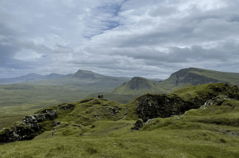
Day 4, 6th stop: Quiraing Walk
Distance from last stop: 15 mins/7 km/4 miles
Time spent here: 2.5 hours
Parking and trailhead: Google Maps link
Hike length: 6 km (12.5 miles) out and back
Difficulty level: Moderate
The Quiraing Walk is the highlight of the Isle of Skye together with Old Man of Storr and Neist Point, so you should be really excited about this stop!
Tip: Read about all of the best spots on the Isle of Skye here.
There is no landscape more Scottish than this. What you see during the Quiraing Walk is what you imagine when you hear the name Scotland—epic, grassy cliffs that dramatically tower up over the sea, getting lost in the clouds.
The views start right at the parking lot and never end. The actual Quiraing Rocks are near the end of the 2-hour circuit walk and aren’t the highlight. It’s one of those spots where the journey is the destination and just being there and seeing the scenery is what it’s about. It’s spectacular.
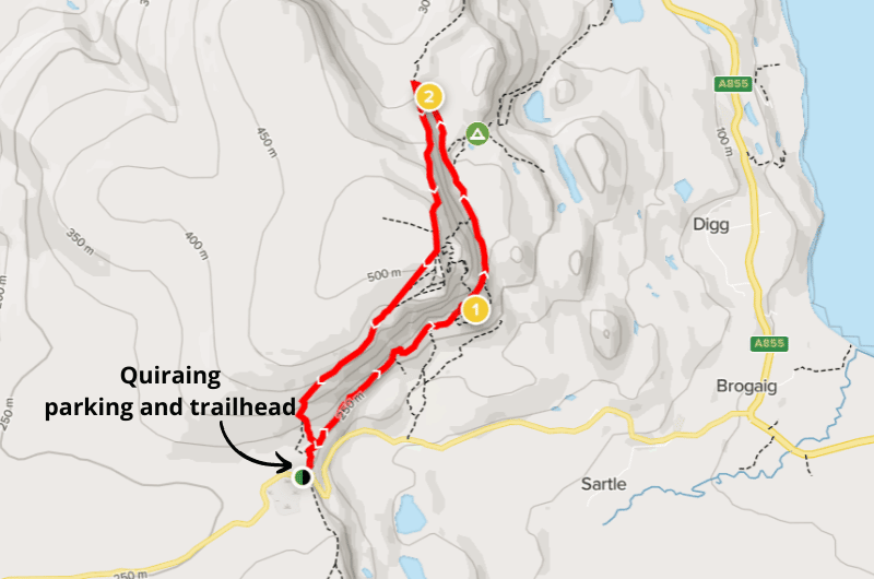
You can also opt for the shorter Prison walk, which is 1 hour there and back—basically just the end of the circular walk.
Google Maps takes you right to the trailhead. There is a parking lot right there at the start, too, and it costs GBP 3 for 3 hours or GBP 5 for 6 hours.
Make sure you dress for bad weather even if it looks like nice weather, and don’t go if it’s raining. That could be dangerous. Some areas of the trail get extremely muddy, are steep, and it just won’t be a nice experience if you’re scared you won’t make it.
More details about the Quiraing Walk and the different trails in our best hikes on Isle of Skye article.
Day 4, 7th stop: Fairy Glen (optional)
Distance from last stop: 20 mins/11.5 km/7 miles |
Time spent here: 30–60 minutes
Parking: Fairy Glen parking, or in Uig if it’s full (1.5 km/1 mile away)
I’m only describing this stop because I know you won’t trust me when I say you can skip it. I thought it was a meaningless stop. We could’ve saved precious time if we’d just driven right past.
Fairy Glen is a valley full of little bumps and rolling hills that looks like fairies would have a blast on. There are some legends about this apparently “otherworldly landscape” that I just didn’t appreciate for some reason.
The parking lot only holds around 20 cars (and costs GBP 5). If you can’t find a spot there, you’ll need to drive to Uig and park there, which would add 1.5 km (1 mile) to your walk.
From the parking lot, you walk maybe 10 minutes before you get to Castle Ewen, which is where you’ll get your first proper glimpse of the glen. You can then wander around until you’re satiated and then head back to the car.
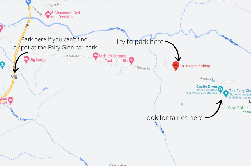
You’ll need a maximum of 30 minutes if you’re like us and maybe an hour if you actually enjoy the place.
There’s no entrance fee to Fairy Glen.
Tip: There’s a cute little eatery close to the Fairy Glen stop called The Galley Café. They make wonderful seafood. There’s seating outside and inside and it makes for a great stop before you head on to your next stop on the itinerary.
Day 4, 8th stop: Dunvegan Castle Gardens (optional)
Distance from last stop: 40 mins/48 km/30 miles
Time spent here: 1 hour
Parking: Public parking lot
I intentionally call this stop Dunvegan Castle Gardens, because I recommend skipping the interior of the castle. It’s just nothing that special, and the gardens are considerably more worth your time. If you look at the ticket price, you’ll see that even the owners agree (you only save GBP 2 if you buy a ticket for just the gardens).
The gardens and the castle exterior are fantastic. The gardens reminded me of Olympic National Park in Washington DC. Take at least an hour to look around.
Parking is free in a parking lot not far away from the castle.
You can also make a quick stop at a viewpoint close by that’s on the way to the next stop on this itinerary, Coral Beach.
More details about our Dunvegan Castle visit in our top things to do on Isle of Skye article.
- Dunvegan Castle
- Google Maps link
- Open daily 10 am–5:30 pm (last entry 5pm)
- Tickets cost GBP 14 for interior and gardens combo, GBP 12 for just the gardens
Day 4, 9th stop: Coral Beach (optional)
Distance from last stop: 15 mins/5.5 km/3.5 miles
Time spent here: 1 hour
Parking: Coral Beach parking lot
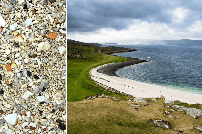
Coral Beach is a 10-minute drive north of Dunvegan Castle. Once you leave your car at the parking lot, it’s about a 2 km (1.2 mile) easy walk to the beach (about 20 minutes).
It’s a beach, but somehow more special. Like everything else on the Isle of Skye. What looks like white sand is made of itty bitty bits of coral (don’t take them home as souvenirs!), hence the name.
There are nice views of the shore and the walk is pleasant. You might even meet a cow. It gets very windy.
Day 4, 9th stop: Neist Point Lighthouse
Distance from last stop: 50 mins/25 km/15.5 miles
Time spent here: 2 hours
Parking: Neist Point parking lot
Neist Point Lighthouse is the westernmost point of the Isle of Skye, which protrudes so dramatically into the sea.
Just to be clear, it’s not the lighthouse that you come here for, it’s the scenery. The lighthouse is just there to look pretty in pictures, you can’t even visit it. It’s just an extremely picturesque place, especially at sunset.
Prepare for a tricky drive on shared-lane roads to get to the parking lot which is right where the trail starts.
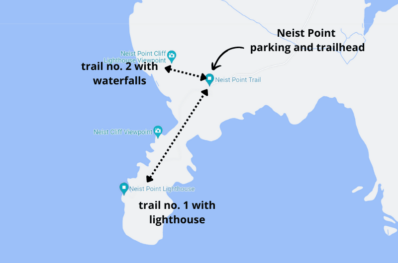
There are two trails from the parking lot: one down to the lighthouse, and one to the right (when facing the lighthouse) that takes you to some more coastal scenery, complete with waterfalls.
It’s common to spot whales and dolphins from the cliffs, so keep an eye out!
You will spend about 2 hours walking around. That said, you can walk to the lighthouse in about 20 minutes, so it’s not so much a long distance than it is photo op after photo op of the incredible landscape.
The drive back to Portree from Neist Point takes about an hour (or only half the time if you chose to stay at Greshornish House Hotel.
Day 5: South of Isle of Skye

Total driving distance: 250 km (155 miles), start in Portree, end in Fort William
Time needed: 8 hours hours plus food stops (without Cuillin Hills hike)
Stops on day 5: Fairy Pools, optional hike in Cuillin Hills, Torabhaig Distillery, Armadale Caste, Eilean Donan Castle
Restaurant tips: Lean to Coffee | Deli Gasta | Red Skye Restaurant
Hotel recommendations: Old Pines Hotel & Restaurant | Clan Macduff Hotel (both in Fort William)
Further reading: Glencoe Highlights | Best Places on Isle of Skye | Best Hikes on Isle of Skye
Today, you’ll explore the southern half of the Isle of Skye and end your day with an overnight in Glencoe Valley, where your trip continues tomorrow.
Day 5, 1st stop: Fairy Pools
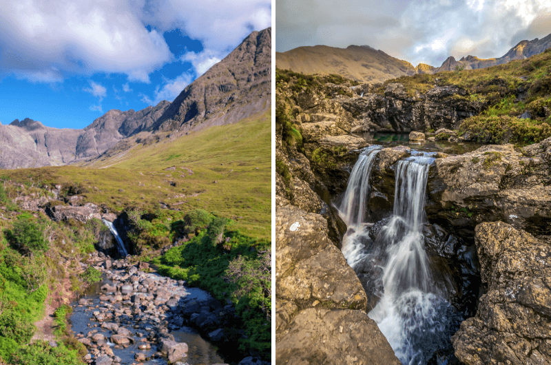
Distance from Portree: 30 minutes/33 km/20 miles
Time spent here: 1–2 hours
Parking and starting point: Fairy Pools Parking Lot
The Fairy Pools are an area of little streams and pools of water and a small waterfall here and there that can look magical in photos against the dramatic rocks in the background. This is only true in good weather when the rocks aren’t all covered in clouds like they were when I went.
Just know that the pools themselves are just ok, you have to look at the big picture to see why the place is so special. Now this feels like a fairies could live here.
Be prepared for crowds. Coming from Drynoch, you’ll be driving on a shared-lane road for the last 10 km (6 miles) before you get to the parking lot, so it could take a while. Parking at the Fairy Pools costs GBP 6.
From the parking lot, it’ll take about 20 minutes to walk to the Fairy Pools, then you can wander around for a bit and head back. About 1 hour total time.
There’s also a loop trail that’s about 5 km long and it takes about 2 hours to complete. The Fairy Pools are surrounded by some of the peaks of the Cuillin Hills, so you’ll get some great views of those as well. This could be a good option if you want to see more nature but aren’t planning on going on a Cuillin Hills hike (see next item).
Day 5, optional extra stop: Hiking in the Cuillin Hills
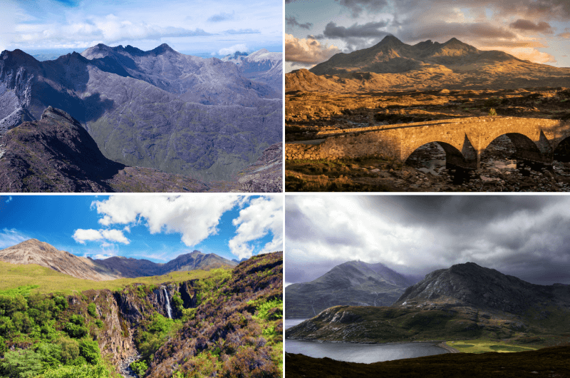
If you’re keen on more hiking, go on a proper hike! I have an article on the best hikes on the Isle of Skye. It would mean a longer day and potentially leaving some other stuff from the itinerary out, but it’s a way tailor these plans to your needs.
The Cuillin is a famous mountain range in the south-central part of the Isle of Skye. It’s also the most challenging mountain range in the UK, though there are some easier walks that the less ambitious folks can go on.
There are many hikes of varying difficulty and length to choose from. You can use alltrails.com (no affiliation) to check out the various routes. Or just trust us to pick the best ones. Head over to our best hikes in Isle of Skye article for details on those.
Most hiking options start in one of two spots: the majority at Sligachan Hotel in Sligachan, like to the peak of Bruach na Frithe, or the flat walk to Sgurr Na Stri, both done in 6–8 hours. Some hikes start at the Glenbrittle campsite, like to Cuillin’s highest peak, Sgùrr Alasdair (6 hours) or to Coire Lagan (a mountain lake), a short hike that you can do in 2 hours.
Glenbrittle is only an extra 10-minute drive from the Fairy Pools parking lot, so it’s easy to add on right after or before the Fairy Pools.
Day 5, 2nd stop: Torabhaig Distillery tour
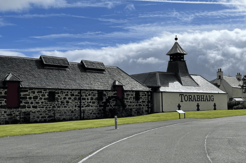
Distance from Fairy Pools: 1 hour/62 km/40 miles
Time spent here: 1.5 hours
Parking: At the distillery
Very much unlike our despicable experience at the Edinburgh Gin Distillery in Edinburgh, this tour was very informative and everyone we met there, from the distillers to the lovely woman at the gift shop, was amazingly welcoming. We loved it there.
Restaurant tip: Some of our favorite restaurants on the Isle of Skye are clustered around the halfway point from the Fairy Pools to the Torabhaig Distillery. Lean to Coffee, Deli Gasta , and the uber-fantastic Red Skye Restaurant will cover you no matter what your food needs are. A quick bite? Sure. A sit-down meal? Yes! Coffee? Check!
The distillery tour takes about an hour, but leave time for some gift shop mayhem and also to enjoy the wonderful scenery.
There is sufficient free parking right at the distillery.
The tours at Torabhaig Distillery get sold out, so make sure to plan accordingly and choose your time slot at least a couple of weeks beforehand.
If you want to learn more about the tour and a little bit about the slightly racist man that founded the place, read our top places on Isle of Skye article.
- Torabhaig Distillery, Teangue, Isle of Skye
- Open Monday to Friday 10 am–5 pm (last entry at 4 pm), Saturday and Sunday 10 am–3 pm (last entry at 2 pm)
- Tickets cost GBP 10, book online ahead of time!
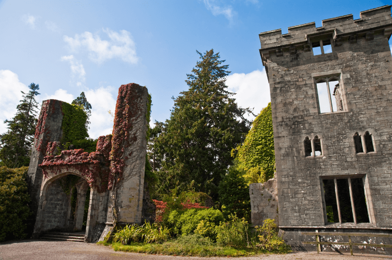
Day 5, 3rd stop: Armadale Castle
Distance from last stop: 10 mins/5.5 km/3.5 miles
Time spent here: 1 hour
Armadale Castle is a ruin that sits right on the coast, with fabulous views to Scotland’s mainland just across the loch (or is it the sea at this point?!). Try to go on a sunny day to appreciate the views, there aren’t many places to hide from the elements at Armadale.
Parking is free.
An exception is the small, award-winning museum attached. It’s very informative and tells the history of the Highlands and islands through the story of Scotland’s most powerful clan, Clan MacDonald.
There are also two cafés on site, one indoor and one outdoor.
If you can’t get enough of the views, check out this nearby viewpoint.
Armadale’s tourist season ends in October, as it does in a lot of Scotland’s castles.
- Open Wednesday through Sunday (only until the end of October) 9:30 am–5 pm.
- Tickets cost GBP 12 for adults.
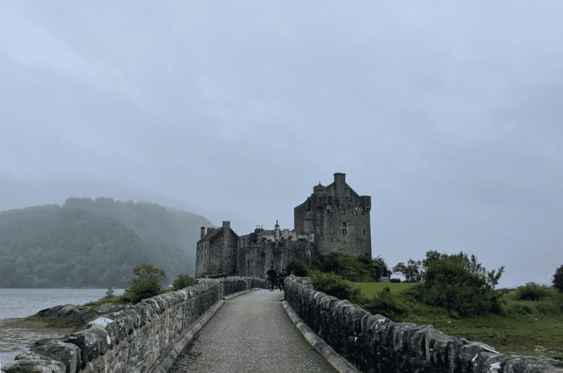
Day 5, 4th stop: Eilean Donan Castle
Distance from Fairy Pools: 45 minutes/48 km/30 miles
Time spent here: 2 hours
Parking: At the Eilean Donan parking lot
I have a personal bias towards Eilean Donan, because it’s the castle from my favorite 80s action movie, Highlander. I was so excited to ge to visit this place, and it delivered!
Eilean Donan is located right after the Skye Bridge on your way off of the island towards your next stop, Glencoe.
It sits on a tiny islet of its own, just a short walking bridge away from the mainland. Sometimes there is almost no water around it, but if you are lucky and manage to see it when the little island is actually an island, it’s magic!
Eilean Donan Castle was originally built to protect the area against Vikings, because it is in a strategic location at the meeting point of 3 lochs/fjords. The castle was destroyed in 1719, lied abandoned for 200 years, and then bought and rebuilt by John MacRae-Gilstrap in 1912. The current owner is a descendant of John’s, is 94 years old and still uses it as a holiday home.
Make sure to set your navigation to Eilean Donan Castle, not just Eilean Donan, or you’ll end up in all the wrong places like we did.
There is a parking lot right before the small bridge to the castle. Parking is GBP 2 per hour.
Allow 2 hours to visit. It’s a self-guided tour with guides on hand if you are extra interested in any info. You don’t need to book tickets to the castle ahead of time, just rock up and in you go.
You can spend some time in the visitor center, gift shop and onsite café, as well.
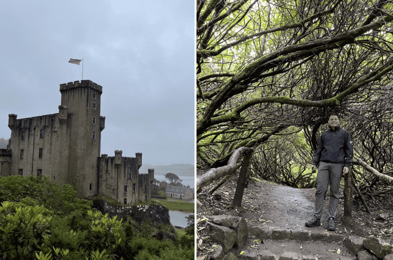
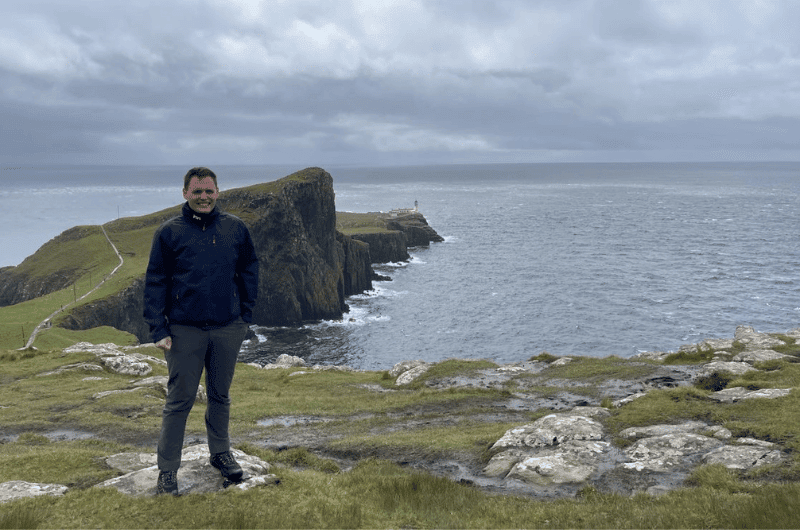
Don’t forget to visit the viewpoint above the castle. You can drive or walk there (on the road). See above photo to see what the view is like (the one with me, Jan, in it).
Note: Eilean Donan is closed when it hosts weddings (which is does a lot of). You can check wedding days on their website.
The drive from Eilean Donan Castle to Fort William, where you’ll be basing yourself for the next 2 or 3 nights, takes 1.5 hours (105 km/65 miles).
Read our article about the best castles in Scotland for more details.
- Eilean Donan Castle website
- Google Maps link
- Open daily 9 am–6 pm (last entry at 5 pm) in the summer months, check other opening times on the website.
- Tickets cost GBP 10 for adults.
Where to stay in Glencoe (for days 5–7)?

Before this day is done, you’ll be checking in to a new hotel. Choose a hotel in Fort William for the best base for your Glencoe exploration.
I would stay at Old Pines Hotel & Restaurant, because the restaurant is absolutely incredible and the hotel is excellent value (and I’m sad I didn’t stay there last time). Both the restaurant and some of the rooms have views of the highest peak in the UK (and one of the best places for a hike in Scotland!), Ben Nevis.
Prices start at GBP 120 for 2 people per night with breakfast.
Alternatively, Clan Macduff Hotel also looks like a great choice and is honestly only other hotel I would choose in Glencoe. If you want reasonable-looking and still reasonably priced, this could be it.
It looks more like a hotel and less like a Cottage. It is 4-star, clean, and with a great staff. Some rooms come with loch views and balconies.
Prices start at GBP 230 for 2 people per night with breakfast.
Day 6: Around Fort William and towards Glencoe Valley

Total driving distance: 135 km (80 miles), start and end in Fort William
Time needed: 8 hours plus food stops
Stops on day 6: Glenfinnan Viaduct, Commando Memorial, Pap of Glencoe
Restaurant tips: Old Pines Hotel & Restaurant | The Geographer (both in Fort William)
Hotel recommendations: Old Pines Hotel & Restaurant | Clan Macduff Hotel (both in Fort William)
Further reading: Glencoe Highlights | Scotland for Couples | About Scotland
Day 6, 1st stop: Glenfinnan Viaduct and Monument
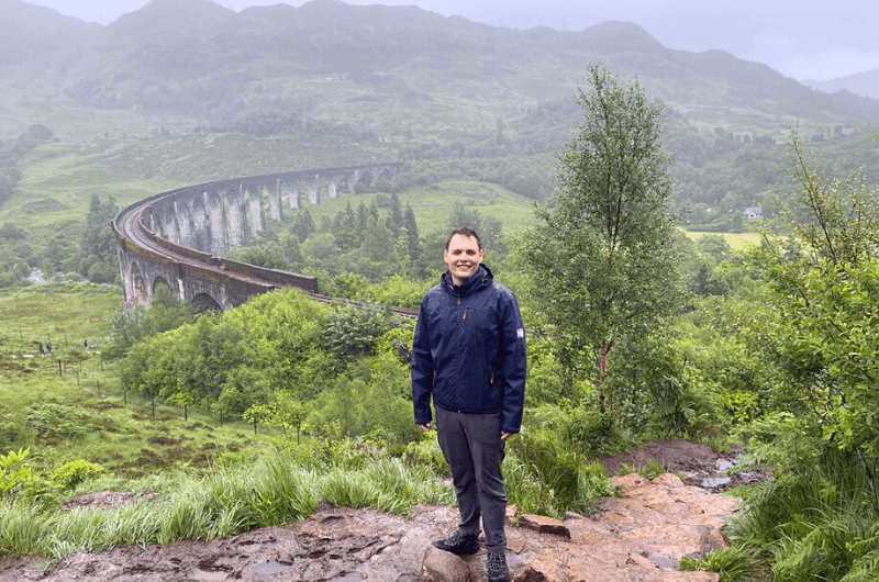
Distance from Fort William: 30 minutes/27 km/16 miles
Time spent here: 2–3 hours
Parking: At the Glenfinnan Viaduct parking lot
Glenfinnan Viaduct is a 120+ year old railway viaduct on the West Highland Line. It is the longest concrete bridge in Scotland, measuring 380 m (1250 ft). It is single track and it has views to Lock Shiel and the Glenfinnan Monument.
For us, one of the best places to visit in all of Scotland.
Even though the Glenfinnan Viaduct featured in several movies (and a video game!), it gained the most fame when it featured in several Harry Potter movies.
Besides the viaduct, you can visit the visitor center, the Glenfinnan Monument, and check out Loch Shiel. All in all, put aside 2–3 hours for the entire visit.
The parking lot is huge, but so are the crowds, especially before train crossings. Parking costs GBP 3.50. We saw a couple of other smaller parking lots close by that could save you in a pinch.
If you want to get the most out of you Glenfinnan Viaduct visit, time your trip so that you are there when the train goes across the bridge. A steam train crosses the Glenfinnan Viaduct twice a day—at 10:45 am and 3 pm, and it is well worth being there for the crossing.
Get there early, since parking can take a minute and then there’s about a 10-minute walk from the parking lot to the viaduct.
There’s a 3.5 km (2 mile) circular trail that you should definitely spend the hour or so walking. The parts further up look like they could be from the Lord of the Rings. The trail takes you past awesome viewpoints of the viaduct and of Loch Shiel, and the Glenfinnan Monument is just off it close to the parking lot.
The visitor center is right by the main parking lot, and I think it’s worth visiting to get an understanding of the Jacobite uprising, which was a huge event in Scottish history. It’s free to enter and is open daily from 10 am– 5 pm for most of the year. There’s a café attached, too.
You can climb up the Glenfinnan Monument for some pretty views over the lake and the surrounding landscape.
You can book your ticket in advance if you really want to be able to climb the monument, since it’s only open for a very short time each day. Honestly I think it’s nice even just looking at it from the ground. Tickets cost GBP 5 per adult (discounts available).
Day 6, 2nd stop: Commando Memorial
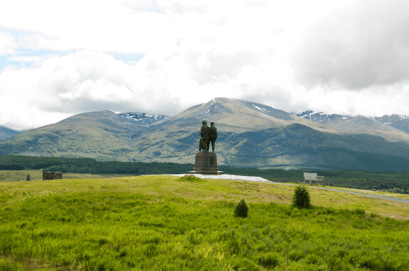
Distance from last stop: 35 minutes/38 km/23 miles
Time spent here: 30–60 minutes
Parking: Commando Memorial parking lot
The Commando Memorial is a bronze statue of 3 army men dedicated to the British Commando Forces that fought during World War II. It was unveiled in 1952 and is one of Scotland’s busiest memorial sites—busloads of people come to see it daily.
It’s popular not just because of the memorial itself, but also because of the views surrounding it. In good weather, you can even see Ben Nevis. The memorial overlooks the former training ground of the soldiers.
Besides the statue, a circular Garden of Remembrance sits nearby, with individual plaques of soldiers that have died in later years—either WWII veterans, or those that fell in more recent conflicts.
It’s a beautiful place that is easy to visit. Parking is free and is right next to the Commando Memorial.
Several hikes start from the memorial, so it’s easy to add a nice walk onto this stop if you have time.
Day 6, 3rd stop: Pap of Glencoe hike
Distance from last stop: 45 minutes/43 km/27 miles
Time spent here: 3–4 hours
Parking: Google Maps link to where you can leave your car
Starting point: Google Maps link to trailhead (go through the gate)
Hike length: About 5 km (3 miles) out and back depending on the trail you choose
Difficulty level: Hard
Known as Sgòrr na Cìche in Gaelic, the Pap of Glencoe hike felt really hard because of the path—it’s either muddy (even in sunny weather!) or super rocky the whole time. Any Heroes 3 fans out there? You need the pathfinder skill to get to the Pap of Glencoe!
It took us 2 hours up and about 1.5 hours to get back down. I definitely wouldn’t take kids or dogs on this trail. Do wear proper footwear.

We really enjoyed the views from Pap of Glencoe, but honestly, the last 100 m-high mound is not worth the extra effort to scramble up. You are already getting the best views when you’re right under it, so unless you are set on summiting, you can turn back without getting all the way to the end.
This hike’s parking area is not visible on Google Maps. You can see the place where you can leave your car here. It’s about 300 m (980 ft) from the trailhead. If it’s full, you need to park in Glencoe and walk the extra 1.5 km (1 mile) to the trailhead.
Speaking of which, the trailhead to Pap of Glencoe also isn’t on Google Maps. Here’s where it starts (close to Strath Lodge). You’ll have to walk through a gate to start, and then it’s just straight up the mountain. There are several trails up, so decide what you want to do beforehand. Alltrails has details on one of the paths here, another trail is here (see just the first half).
Day 7: Glencoe Valley

Total driving distance: 180 km (110 miles), start in Fort William, end by Loch Lomond
Time needed: 11 hours plus food stops
Stops on day 7: Ben Nevis hike, James Bond Road
Restaurant tips: The Geographer in Fort William | The Pier Kitchen & Bar in Balloch
Hotel recommendations: Queen of the Loch, Balloch by Marston's Inns | The Lodge On Loch Lomond Hotel (both by Loch Lomond)
Further reading: Best Places in Glencoe | Driving in Scotland | About Scotland
You’re almost in the final stretch! One last big hike and then you start heading back down south towards Edinburgh. But you don’t drive all the way quite yet—you make a stop halfway for 2 nights in order to explore some beauty along the way.
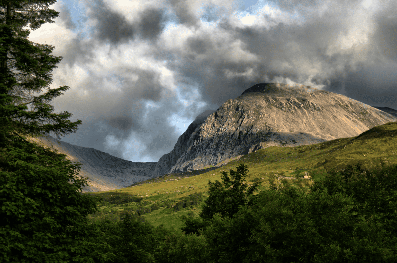
Day 7, 1st stop: Ben Nevis hike
Distance from last stop: 45 minutes/43 km/27 miles
Time spent here: 7–9 hours
Parking and starting point: Ben Nevis Visitor Center
Hike length: 15 km (3 miles) out and back
Difficulty level: Hard
Ben Nevis aka The Ben is Scotland’s iconic mountain and the highest peak in the UK at 1345 m (4412 ft).
Climbing it takes the better part of a day, but it can be done by beginners.
You’ll be starting almost at sea level, so the elevation gain is significant. The first half is a walk up a mostly stony or gravel-y trail, and the second half is a zig-zag rocky trail that’ll have you unsure whether to look under your feet trying not to trip, or at the awesome views.
Remember it is always necessary to have a map, a compass, and good clothing—Scotland’s weather changes its mind very frequently and you don’t want to get lost. There is no signposting on the trail, though it is mostly easy to see. About 1000 people go on the Ben Nevis Walk every day in the summer months, so you won’t be alone.

You’ll get all the information you need at the Ben Nevis Visitor Center near For William, which is also where you’ll start your hike.
There’s easy parking at the visitor center.
Walking up Ben Nevis makes sense mainly in good weather, because if you have to hike through clouds, you’ll see diddly squat at the summit. A good app for weather is AccuWeather, or you can check the latest forecast at the Mountain Weather Service website.
Tip: When you summit Ben, you can cross off your first Munro and take up a new pastime—Munro baggin! If you want to know why you are now baggin’ things and why it’s a popular hobby for the British, check out our Scottish fun facts.
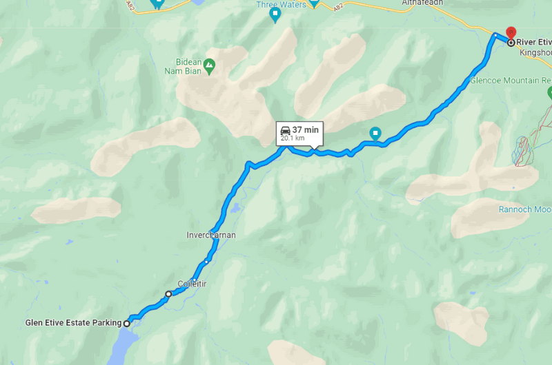
Day 7, 2nd stop: James Bond Road
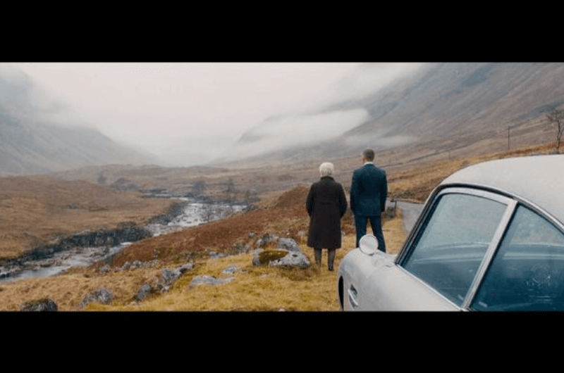
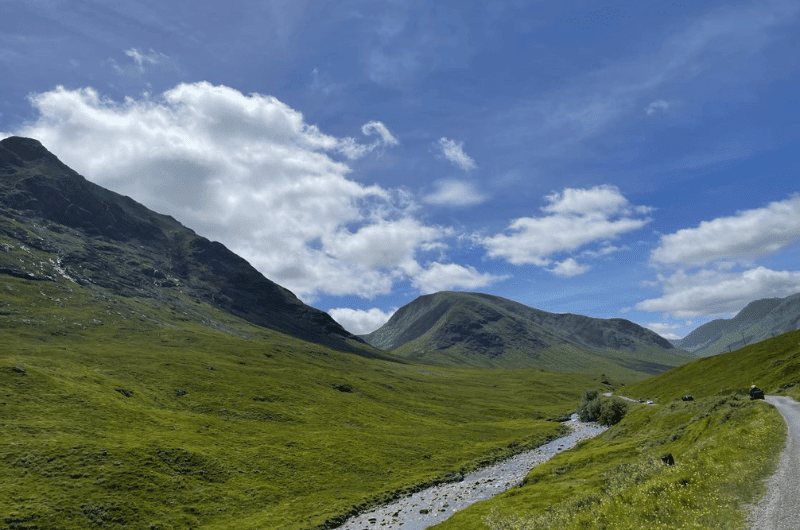
Distance from last stop: 20 minutes/20 km/12 miles
Time spent here: 1.5 hours
Scenic road starting point: Near the River Etive Bridge
Scenic road length: 20 km/12.5 miles
James Bond Road, famous for being featured in the 2012 James Bond movie, Skyfall, is a scenic road of 20 km (12.5 miles) between the A82 and Loch Etive.
It’s easy to navigate, but it is single lane, so be prepared for it to take time to drive through while letting others pass or stop to take photos. You then need to drive the same way back again, so don’t hurry and just take in the magnificent views of Glen Etive.
There are spots on the way where people stop and take photos of the most beautiful and famous parts. If you do this (you will want to), just keep traffic moving and don’t linger too long. Sometimes there’s only room for one car, so take your pic and get out of there.
Tip: Do you love scenic roads? Check out my tips for driving in Scotland which include how and where to drive.
The last thing you need to do today is get yourself to the Trossachs National Park, where you’ll be spending the next two nights.
The best places to stay in Trossachs National Park (for days 7 and 8)

The biggest town on Loch Lomond is Balloch at its southernmost point. This is where you’ll find a relatively good selection of eateries, as well as many apartments and B&Bs. To be honest, there isn’t a lot to choose from as far as good-value hotels or lodges. Everything’s either expensive or doesn’t look very nice.
For a place in town, I’d go for Queen of the Loch, Balloch by Marston's Inns, which is a nice, clean place with its own restaurant and very welcoming staff.
Prices start at GBP 100 (USD 120) per night (2 people) including breakfast.

If you expect more stars, 4 to be exact, and don’t mind being out in the boonies surrounded by nothing by nature, The Lodge On Loch Lomond Hotel ticks all the boxes and is right on Lomond’s shore.
The restaurant serves wonderful meals, the rooms are up to standard and the scenery is just to die for. If this lodge is your style, then go for it.
Prices start at GBP 180 (USD 115) per night (2 people) including breakfast.
Day 8: The Trossachs National Park

Day 8 itinerary on Google Maps
Total driving distance: 150 km (95 miles), start and end in Balloch
Time needed: 5 hours plus food stops and time at Loch Lomond at the end of the day
Stops on day 8: Inveruglas Pyramid, Falls of Falloch, Ben Aan hike, Duke’s Pass, Loch Lomond
Restaurant tips: Puddingstone Place in Callander | The Pier Kitchen & Bar in Balloch
Hotel recommendations: Queen of the Loch, Balloch by Marston's Inns | The Lodge On Loch Lomond Hotel (both by Loch Lomond)
Further reading: Best day trips from Edinburgh | Driving in Scotland | Scotland Fun Facts
The Trossachs are 1900 km2 (720 square miles), which is a lot of national park to cover on foot! Luckily, you can drive around and partially through the park in your car, making stops along the way and enjoying the nature. This road is one of my favorite scenic drives in Scotland and it circles the entire park.
Day 8, stops 1–2: Viewpoints and waterfall

Distance from Balloch: 45 minutes/47 km/29 miles
Time spent here: 20 minutes at each stop
Parking: Inveruglas Pyramid parking, Falls of Falloch parking
Since the park is so big, it can be hard to know where to stop for the best views. Lucky for us tourists, the National Park held a competition in 2015 to find and design the best viewpoints in the Trossachs. Four of those designs are now available for you to see.
The first two are close to each other at the northern end of Loch Lomond.
Inveruglas Pyramid is first when driving north on the A82 from Balloch. It’s almost at the northern tip of Loch Lomond. There’s a parking lot (50 p for 30 minutes) only a short walk away from the viewpoint. Expect stairs.
Woven Sound is 15 minutes further up the road, this time next to the Falls of Falloch, a waterfall that’s only a 5-minute walk from the parking lot. Parking is very limited, so I’d aim to arrive early. Note that it is illegal to park on the A82, so if you can’t find a spot, you might need to miss this stop.
Optional: The other 2 viewpoints are a mirrored box on Loch Voil and a little picnic area by Loch Lubnaig. Stop there if you feel like it. By the time you reach the last viewpoint, you’re almost at the turn off for the next stop, Ben Aan, so I’d just head straight there—the views are spectacular!
Day 8, stop 3: Ben Aan hike

Distance from last stop: 45 minutes/43 km/27 miles
Time spent here: 2 hours
Parking and starting point: Parking right off the A821
Hike length: 4 km (2.5 miles) out and back
Difficulty level: Moderate
Three quarters into the Trossachs loop drive, you’ll turn off the A84 onto the A821. This is where you’ll want to stop for the best hiking route of the Trossachs—Ben Aan.
You park right off the A821 and the 4 km (2.5 miles) return trail starts right there and takes about 2 hours total to complete. It has an elevation of about 350 meters (1100 ft) and can be steep at some points, but the great views (that never stop!) totally beat any feelings of fatigue along the way.
The trail is in very good condition, so I think it is the right fit for almost everyone—even the unfit.
Hungry? If you need to grab lunch before the hike, I recommend Puddingstone Place in Callander on the A84.
Day 8, stop 3: Duke’s Pass

Distance from last stop: 0 minutes, the pass basically starts at the Ben Aan parking lot
Time spent here: 20 minutes just driving on the pass, extra time if going to Loch Katrine
Following the Ben Aan parking area is the start of the Duke’s Pass, a formerly private road that connects Loch Katrine to Aberfoyle and is now super popular with tourists because of the scenery you get to witness from it.
Duke’s Pass was built in the by the Duke of Montrose in the 19th century. The pass twists and turns for 11 km (7 miles) and offers wonderful views of the Trossachs.
If you feel like a little extra lake scenery, you can take a boat tour on a little steamship on Loch Katrine before you continue down the pass. There’s also a visitors’ center there if you are interested in doing any walks in the area.
Day 8, stop 4: Loch Lomond

Distance from last stop: 30 minutes/30 km/18 miles
Time spent here: 20 minutes
After all that driving, it’s time to just rest and enjoy the rest of your day by the lake. Lake Lomond that is.
Loch Lomond is one of the largest bodies of freshwater in Britain, so it provides plenty of room for paddling in a rental boat or just relaxing or walking on some of the beaches. You can also ride a jet ski, cycle along the lakes, swim, or go kayaking.
For more information on all the water activities available, check out the Loch Lomond website.
You’ll spend one more night in your Loch Lomond accommodation before moving on to Edinburgh tomorrow.
Day 9: Stirling

Total driving distance: 115 km (70 miles), start in Balloch, end in Edinburgh
Time needed: 8 hours plus food stops
Stops on day 9: Stirling Castle, Wallace Monument
Restaurant tips: Henderson's Bistro Stirling | Vesta Bar & Kitchen in Edinburgh
Hotel recommendations: Leonardo Edinburgh City | Virgin Hotels Edinburgh
Further reading: Edinburg Day Trips | Best places in Edinburgh | Driving in Scotland
Day 9, stop 1: Stirling Castle

Distance from Balloch: 45 minutes/48 km/30 miles
Time spent here: 5 hours
Parking: Stirling Castle parking lot
Stirling Castle is beautiful from the outside and interesting to visit on the inside. It sits on top of a volcano and looks very dramatic. Stirling Castle topped my list of the best day trips from Edinburgh.
It’s the most important castle in Scotland’s history as it’s the most strategically located and for a long time it was the seat of Scotland’s kings. The place was so important that during the 1300s it changed hands 8 times! Everyone and their uncle wanted to call Stirling their home.
Stirling Castle is full of Scottish history information in the form of fun facts and interactive exhibits, which is really nice and makes for an enjoyable and non-stuffy visit. Even if you don’t know anything about the country’s history when you come in, you’ll certainly come out an expert.
Stirling Castle is big enough to take up the better part of your day—we spent 5 hours there.
The location is—surprise!—in a town called Stirling.
There is big parking lot and you need to buy your tickets in advance. Tickets are time-slotted.

The castle is divided into different areas, each showcasing a different exhibit. For example, there’s a section that explains all about the Scots kings and their mistakes and how they ruled.
Another exhibit is dedicated to the most famous and probably the most important Scots king, Robert the Bruce, and Battle at Bannockburn of 1314 (check out the nearby monument).
There’s also a great museum dedicated to the Argyll Highlanders, one of the most important regiments of Imperial Britain.
Then there’s the kitchen, the tapestry exhibit, the royal chapel, the gardens… I told you, the place is huge!
The Unicorn Café is onsite and serves simple food and drinks.
Tip: If you like large palaces filled to the brim with interesting information, read about our visit to the Topkapi Palace in Istanbul. That also ate up a huge part of our day. It was so good!
- Stirling Castle website
- Google Maps link
- Open daily 9:30 am–6 pm (5 pm in the winter months).
- Tickets cost GBP 16.50 for adults when bought online and GBP 18 at the gate.
Day 9, stop 2: Wallace Monument

Distance from last stop: 10 minutes/3.5 km/2.5 miles
Time spent here: 2 hours
Parking: Wallace Monument parking lot
The Wallace Monument is an amazing spot that I urge you not to miss. Granted, I’m a Braveheart fan, but I think you’ll enjoy the exhibit and the views even if you aren’t.
It is on top of a hill, too, so expect a bit of a walk to the entrance from the (free) parking lot. There’s also a shuttle bus available if you need a little help getting up the hill.
It’s advised to book tickets online ahead of time, because space is limited and tickets are time slotted.
The monument even holds William Wallace’s original sword, and then you can take a photo holding a fake one, pretending to be the real Wallace. You can read up on the story before you go on the monument’s website.
As is usual in Scotland the tour is interactive. So interactive, in fact, that you can make your own banner for the shield before taking the photo, much to every kid’s (and big kid’s) appreciation!
The monument is based on historical reality. As such, it focuses not only on William Wallace, but also Robert Bruce.
The tower is divided into floors and each floor is dedicated to the different topic. The tower is 60 m (almost 200 ft) tall and there are 3 floors. Expect a steep and narrow staircase.
There are great views from the top of the tower.
Along the walk up through Abbey Craig, you’ll already start exploring the history of Stirling through woodcarvings on the way.

I say set aside 2 hours to visit. Maybe less if you aren’t such a Wallace fanatic, but still, be prepared to want to pay attention to all the educative bits that are available, because they really are interesting.
Parking is available for free by the Legends Coffee House at the foot of the hill.
- Wallace Monument website
- Google Maps link
- Open daily year round, opening times differ throughout the year. Summertime opening times are 9:30 am–6 pm.
- Tickets cost GBP 10.75 for adults.
The day isn’t over yet, because you still have to drive 1 hour to Edinburgh’s city center, which is where you’ll say goodbye to Scotland the day after tomorrow.
For dinner, I recommend Vesta Bar & Kitchen in Edinburgh. Maybe you’ll meet a famous actor there like I did.
The best places to stay in Edinburgh (days 9 and 10)
It’s your last two nights in Edinburgh, so you’ll want a nice hotel to crash at. Edinburgh’s hotel prices tend to run high (just like everything else in the country), so we dug high and low for the best places to stay that won’t bankrupt you but still give you a comfortable stay.
This is the hotel we stayed at and were happy, followed by the hotel we would’ve stayed at if we wanted to spend double the money on it:
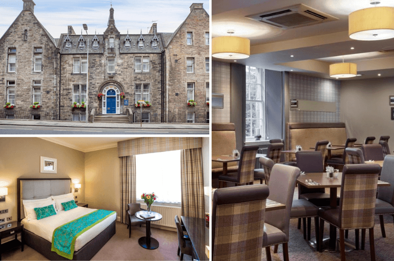
The Leonardo Edinburgh City is where we stayed when we visited Edinburgh and I would stay there again. I don’t think there’s anything comparable in Edinburgh as far as bang for your buck.
Not to be confused with at least 2 other hotels in Edinburgh under a similar name.
Prices for two start at GBP 140 (USD 160) per night including breakfast.
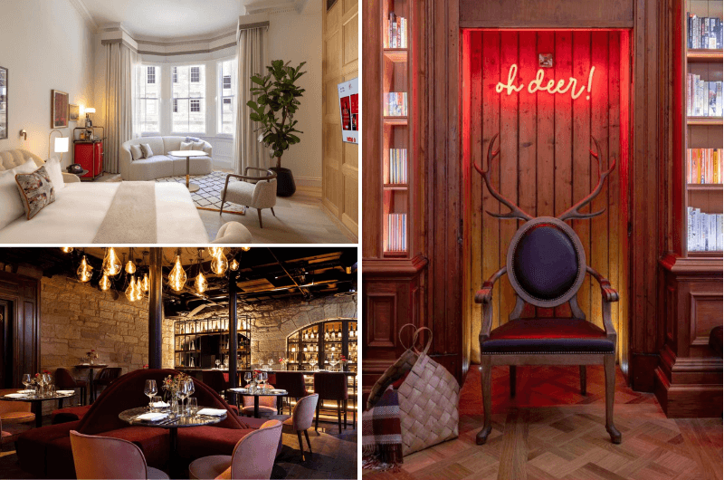
I think the best place to stay in Edinburgh is the 5-star Virgin Hotels Edinburgh. I didn’t stay there due to “budget differences”, but the cool style and service the reviews mention cannot be beat.
Prices for two start at GBP 320 (USD 365) per night with breakfast.
Day 10: Edinburgh

Total distance: leave the car at the hotel, you’ll be walking today
Time needed: 9.5 hours plus food stops
Stops on day 10: Greyfriars Bobby statue, Edinburgh Castle, Royal Mile, Holyrood Palace, Arthur’s Seat
Restaurant tips: Wedgwood Restaurant | Dine Murrayfield
Hotel recommendations: Leonardo Edinburgh City | Virgin Hotels Edinburgh
Further reading: Edinburg Day Trips | Best places in Edinburgh | About Scotland
I’ve planned 5 stops for today. They are the highlights that I think you shouldn’t miss, but there is so much more to see in Edinburgh, it won’t hurt to add a day if you can. For the complete list of what’s worth seeing in the city, see my article on the Best Places in Edinburgh (there are 15 of them).
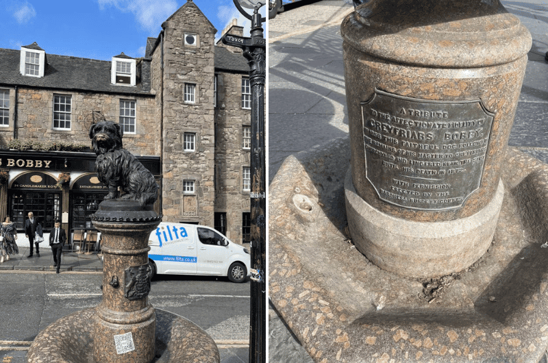
Day 10, stop 1: Greyfriars Bobby statue
Time spent here: 20 minutes
Distance to next stop: 10 minutes/550 m/0.3 miles
Ok, it’s a statue of a dog, which might not sound like much, but what a story! I may or may not have been told in the past that I have a heart of ice, but boy this story melts it! It’s basically a monument to loyalty.
Bobby (the Skye Terrier or Dandie Dinmont Terrier) belonged a night watchman at the Edinburgh City Police named John Gray. His trusty dog would stay by his side during all his shifts, and then, when John died, stayed by his grave at Greyfriars Kirk. For no less than 14 years!! Incredible!
Bobby died in 1872 and is now buried at the same cemetery as John Gray, so head there as well to see them both.
Greyfriars Bobby has melted many hearts, not just mine, and got his own statue shortly after his death (the cemetery entrance is just across the street from the statue).
- Greyfriars Bobby statue: corner of Candlemaker Row and George IV Bridge
- Greyfriars Bobby grave: near the entrance at the Greyfriars Kirkyard, 26A Candlemaker Row
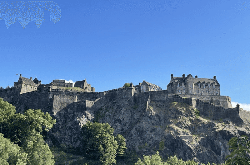
Day 10, stop 2: Edinburgh Castle
Time spent here: 3 hours
Distance to next stop: 0 km—the Royal Mile starts at the Edinburgh Castle
Atop a volcano plug (called Castle Rock), towering above Edinburgh’s Old Town, is Edinburgh’s most visited attraction, Edinburgh Castle. The views and the castle itself are spectacular!
The highlight is supposed to be the Scottish crown jewels, which are nice and very old (the oldest in the UK), but castle itself is better.
The entire complex is pretty big, so make sure you set aside enough time to see it all—it's easy to spend 3 hours there. The castle feels a bit disorganized as there is a lack of maps, which can slow you down.
You can get your tickets online, which I highly recommend you do, especially in the summer months, or you might not even get in. Tickets are for a specific day and time, meaning you have to enter at a set time, though you can then stay as long as you want (but! some sites have a 2-hour time limit). Audio guides cost extra and are not needed if you speak English.
Tip: The Edinburgh Castle website has a number of itineraries that you can follow depending on how much time you have and where your interests lie.
Scotland has some of the best museums and castles I’ve seen (rivaling Belgium’s museums). They really try hard not to bore you to death, so most of what you get is fun facts and it’s all interactive and interesting. This is true at Edinburgh Castle as well.
The National War Museum is part of the Castle complex and is great for history and war geeks like me. There is also the nicely laid out Royal Scots Dragoon Guards Museum which will make you feel like a little boy again, because of all the stories about heroism.
Almost at the end of the castle there is a very nice audio-visual exhibition of Stirling Siege.
The museums inside are free to enter, because you can’t get to them without buying the Castle tickets.
Tip: If you want to take a good photo of Edinburgh Castle, either head to the popular Vennel Viewpoint or, to the (in my mind) even better Scott Monument.
- Open daily 9:30 am–6 pm April through September, closes 5 pm during October through March. Last entry 1 hour before closing. Museum opening times can vary.
- Tickets cost GBP 18 (family and other discounts available). Tickets can be bought online.
Day 10, stop 3: Royal Mile

Time spent here: 30 minutes just to walk the mile, several hours with stops
Distance to next stop: 0 km, Holyrood Palace is right at the end of the Royal Mile
The Royal Mile is literally a 1-mile long, really old street (that’s 1.6 km in normal people measurements) with Holyrood Palace on one end and Edinburgh Castle on the other. It’s a nice walk and all of Edinburg’s best places to visit are on or close to it.
Expect lots of shops and restaurants here as well, like the amazing Wedgwood Restaurant (my tip for a fantastic lunch or dinner!).
The bagpipe players along the Royal Mile add to the Scottish atmosphere.
Along the way, or in the lanes just off of it, you’ll find some of the other best attractions to visit in Edinburgh, like St Giles’ Cathedral, Camera Obscura & World of Illusions, and the Edinburgh Dungeon.
Possible detour: As I mentioned in the previous stop, the views of the Edinburgh Castle I liked best were from the Scott Monument. The marble monument is about 0.5 km (0.3 miles) north of the Royal Mile. It’s dedicated to writer Sir William Scott, and includes 64 figures + Scott and his dog.
It doesn’t look like there’s a staircase in there, but alas, it fits! Barely. You can climb the claustrophobic, itty bitty staircase to see some great views from the top. You can take a breather on the 1st floor in the Museum Room and learn about Scott and the monument.
A place Harry Potter fans might want to stop at is J.K. Rowling’s handprints—there’s a tile on the ground right across from St. Giles’ Cathedral that she stuck her famous hands into.
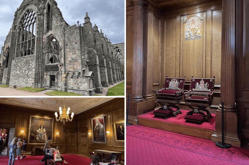
Day 10, stop 4: Holyrood Palace
Time spent here: 2 hours
Distance to next stop: 5 mins/300 m/0.2 miles
Holyrood Palace is on the opposite end of the Royal Mile to Edinburgh Castle.
I usually don’t like official palaces of royals, because they tend to be boring. This one, though, is really ready for tourists and there’s a nice history of the palace and current royal family and how they use it. Stirling Castle it ain’t, but it’s interesting enough to pay a visit.
Holyrood is an official royal palace of Scotland, and it was built in 1503. First, it served the Scottish kings and now the Royal Family stays there while visiting Edinburgh.
An audio/video guide is included in the ticket price, so don’t forget to pick one up at the entrance. The audio guide tells you stories of past kings and queens and it gives the whole place deeper meaning.
Amongst other parts, you’ll be able to visit the state apartments, which get bigger and grander as you approach the king’s bedroom. There’s also the Throne Room, which is used for state functions and to accept important visitors, and the largest room in the palace, the Great Gallery. That’s where you’ll see 95 portraits of kings and 1 queen of the Stuart dynasty.
If visiting in spring or summer, you’ll also enjoy a stroll in the palace gardens.
Holyrood Abbey is currently closed to the public (2022).
Your ticket to Holyrood Palace includes a multimedia guide. You can buy tickets online.
Holyrood Palace stands in the shadow of the inactive volcano of Arthur’s Seat and the hike up there starts nearby and is the next point on our list.
- Holyrood Palace website
- Google Maps link
- Open daily in the summer 9:30 am–6 pm, check website for opening times during other months (Holyrood Palace is open year-round)
- Tickets cost GBP 18 for adults
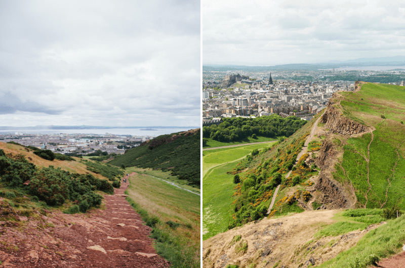
Day 10, stop 5: Arthur’s Seat
Time spent here: 2.5 hours
Arthur’s Seat is part of a volcano that juts out of the Earth right next to Holyrood Palace, perfectly across from Edinburgh Castle, which means more views! This time with no man-made structure on top, this is an easy nature hike that’ll give you Edinburgh on a golden platter.
There are several trails for the Arthur’s Seat hike, most of which are clearly visible on Google Maps. What you will want to see are the Salisbury Crags and Arthur’s Seat itself.
I suggest doing a loop hike which takes you through both, gives you the best views, and there’s no backtracking. It’s an easy hike with some moderate areas in the short section down from Arthur’s Seat to Salisbury Crags.
The trails on the Arthur’s Seat hike are a combination of dirt trails, stone steps (on the way from the top), and paved walks down in the park or at the final section from the Salisbury Crags.
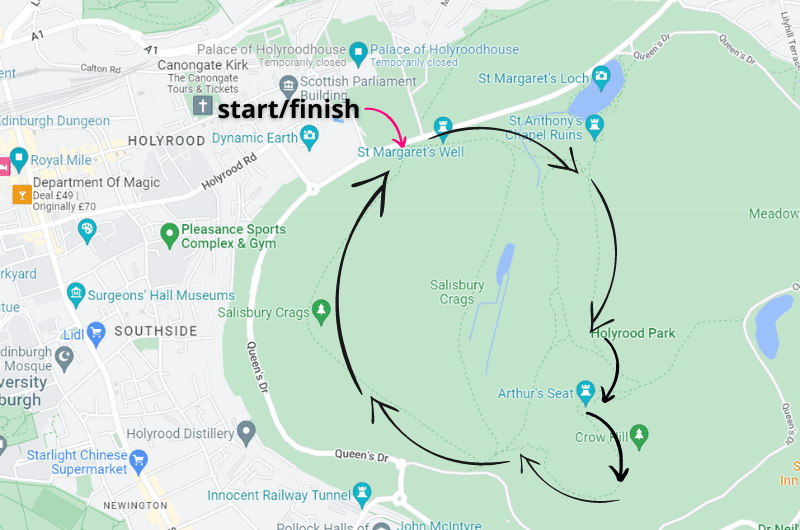
If you look at the Arthur’s Seat map that I’ve whipped up for you, you can see which trails to take. You start close to Holyrood Palace and take the dirt trail that will be on your left (you can get there on the paved one to the right as well, but the left will give you much nicer views!).
You’ll get to the Arthur’s Seat in about 40 minutes.
When you’re done staring down at Edinburgh city center, you start your descent. Take a dirt road that is part stone steps, until you reach a fork in the road. You’ll want to take either the wide, paved (official) trail that takes you underneath the Salisbury Crags, or you can walk along the tops of the Crags. You’ll see it’s been walked, so no worries. Just don’t fall off the cliffs.
You’ll be back at the starting point in 2–2.5 hours total.
It gets crazy windy at Arthur’s Seat all year long, so come prepared with a jacket even if Edinburgh city center feels balmy.
FAQs: When’s the best time to visit Scotland?

We visited in July and still got snow in the Highlands, so it’s obvious you want to avoid visiting in the winter months! Many hiking paths aren’t even accessible and some tourist sites such as castles close up completely in the winter.
Visit Scotland between May and September for the best weather, but still prepare for the worst weather.
FAQs: What clothes should I pack?

Bring proper clothing! Always expect rain, mud, and crazy wind that will creep into even the best of softshells, especially since you’ll be visiting the Scottish Highlands.
We got snow in the middle of July. And when I say proper, waterproof gear, I don’t mean that ok-ish jacket you can wear when you go on a little forest walk back home.
The advice I wish someone would’ve given me (and strongly insisted I take it) in preparation for a Highlands visit: Pack high quality waterproof clothing! We had to buy all new jackets and shoes in Scotland after the stuff we took was deemed utterly insufficient about 7 minutes into our trip. And we had good gear! Just not Scotland-ready gear. That’s a whole other level.
FAQs: A note on restaurants in the Scottish Highlands

Always book restaurants in the Scottish Highlands in advance. It might seem unnecessary but trust me.
On the Isle of Skye there were so many visitors that we stopped at about 10 restaurants, not kidding, before we found a place to eat on our first day. We quickly learned our lesson and made restaurant booking for the next days.
Even in Assynt, which feels like the end of the Earth with nobody there, has restaurants that are full or tourists at all times. Book ahead!
This post contains affiliate links. I earn a small commission if you make bookings through my links, at no additional cost to you. This helps us keep this blog free, thank you!
Comments
Thoughts? Give us a shout!