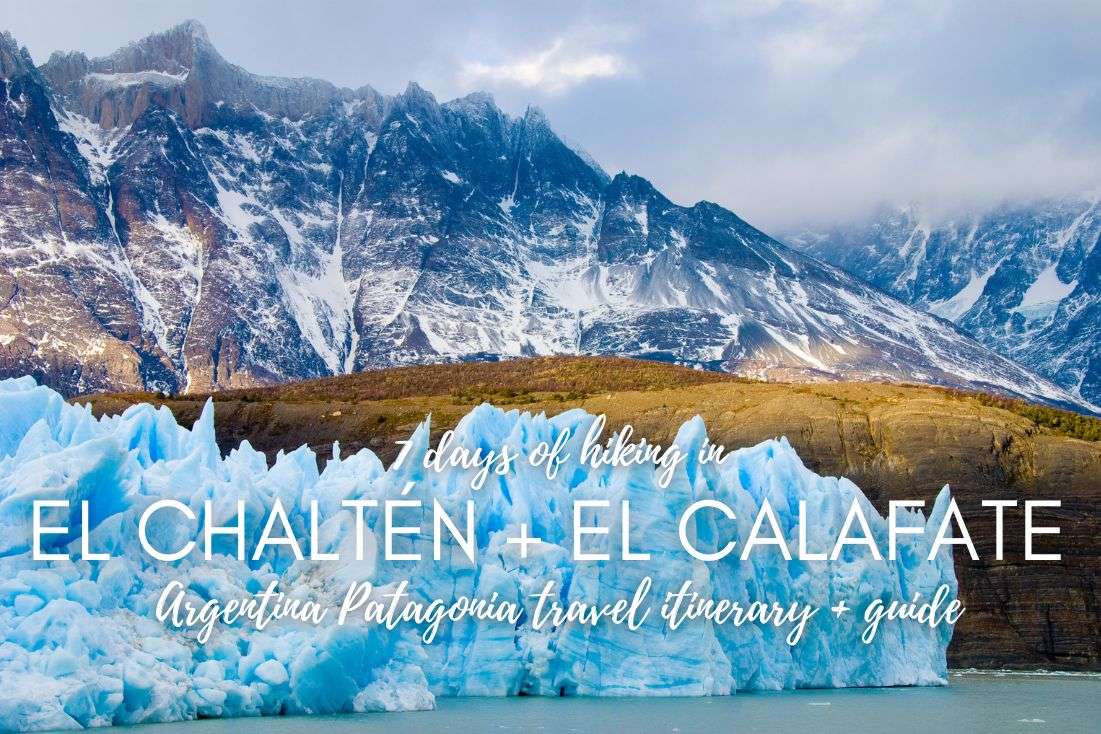
Argentina Patagonia Travel Itinerary and Guide: 7 Days of Hiking in El Chaltén and El Calafate

Argentina's Patagonia is, without a doubt, one of the most visually striking places I've ever seen. Seriously, if you’re into huge pale blue glaciers and massive granite pillars, then this place is going to blow your mind. But let me tell you, the most stunning view of all time is the Southern Patagonian Ice Field—it's jaw-dropping and immense.
Los Glaciares National Park is a hiker's paradise and giving it anything less than 7 days is bonkers. If you're anything like me—a hiking enthusiast who loves exploring natural wonders—then this spot needs to be at the top of your bucket list. Imagine a land where rugged peaks, pristine lakes, and ancient glaciers come together to create some of the most spectacular scenery on Earth.
What you’re reading is a detailed trip itinerary for a 7-day Patagonia trip with bases in El Chaltén and in El Calafate so you can explore Los Glaciares National Park to its fullest potential. I’ll take you through the best hikes and other things to do like kayaking, rafting, and museums, tell you where to stay and how to get between the two towns, as well as answer tons of other FAQs so you’re ready to plan your trip like a pro.
Are you ready to experience the awe-inspiring and totally jaw-dropping landscapes of Argentina’s Patagonia?? This place is unreal—you’ll go on some of the best hikes and outdoor experiences you'll ever have. Like, in your entire life.
Argentina Patagonia itinerary overview + map
Day 1: Arrival in El Calafate, Drive to El Chaltén, Mirador de los Cóndores hike
Day 2: Warm-up hike to Laguna Torre
Day 3: Iconic hike to Laguna de los Tres, rest
Day 4: Whitewater rafting, hike to Laguna Azul and Laguna Verde
Day 5: Hike to Laguna Capri, drive to El Calafate
Day 6: Wooden walkways and kayaking at Perito Moreno, Glaciarium
Day 7: Ice walk/Ice climb in Perito Moreno
Day 8: Departure from El Calafate
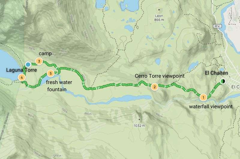
Los Glaciares National Park orientation
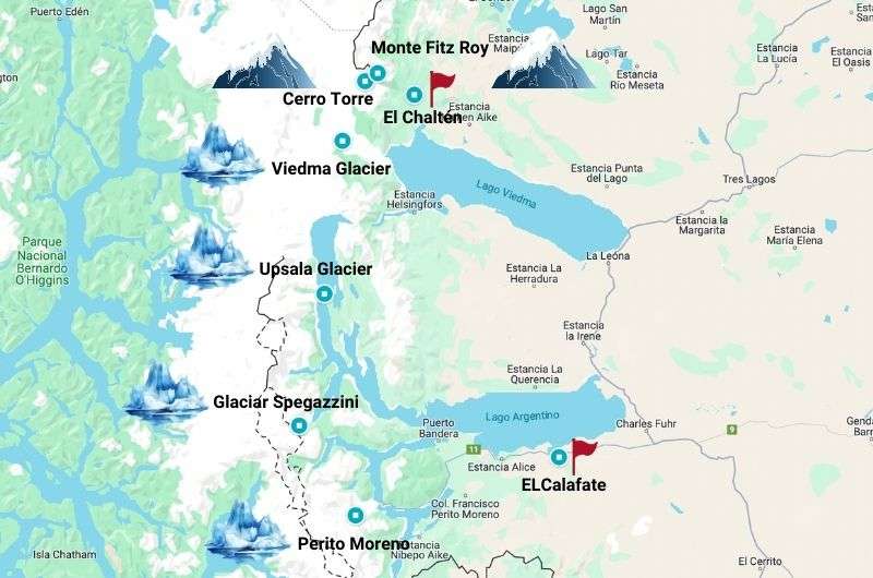
Map of Los Glaciares National Park and my graphics skills (get the map on Google Maps)
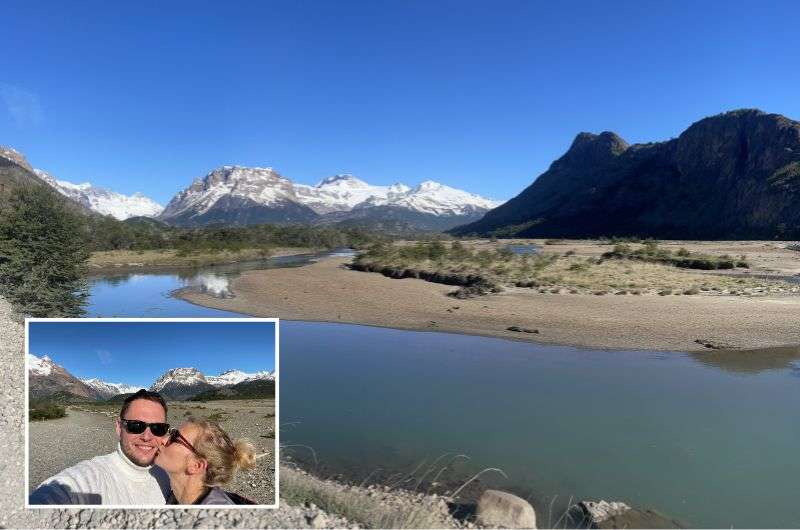
Los Glaciares National Park is a vast protected area located in southern Argentina, specifically in the province of Santa Cruz, bordering Chile. The park spans an incredible 4,459 km² (1,720 mi²)--which is bigger than the island of Mallorca or Rhode Island in the US. It’s famous for its stunning glaciers, clear lakes, and impressive mountain scenery. And when I say impressive, I mean you won’t believe your eyes—it’s epic!
>>Which is better: Patagonia in Argentina or in Chile?? See which country scored more spots on my top hikes in Patagonia list<<
Your bases: El Calafate and El Chaltén
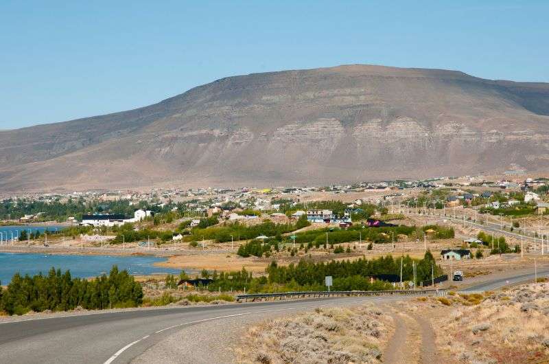
El Calafate, situated on the shores of Lago Argentino, serves as the gateway to Los Glaciares National Park and is a laid-back base for tourists, mainly thanks to the nearby airport and the Perito Moreno glacier that is the highlight. It sits in the middle of the pampas, with some pretty epic views of the mountains around it. The city has a population of about 22,000, but it developed from a small village inhabited primarily by park rangers.
Enjoy your time in Los Glaciares National Park!
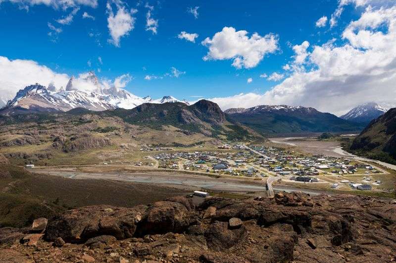
El Chaltén, on the other hand, is a small town nestled in the heart of Los Glaciares National Park in the northern section of the park, is dubbed the hiking capital of Argentina. It has this Lake Tahoe sport vibe that I thought was really nice. The population is only about 1,600 people, but surprisingly, the locals here speak decent English, unlike the rest of Argentina. It doesn’t feel like you’re in a Spanish-speaking country at all—more like Norway or Oregon.
El Chaltén is a small town surrounded by big glaciers, mountains, and lakes
No matter if you’re in El Calafate or El Chaltén, everyone is wearing hiking boots and functional clothing, and it’s clear why they’ve come here. To party! Wait, no… but they do party too, a lot actually. In functional clothing, naturally, which is pretty tasteless in my opinion! I’m not a fashionista, but how hard is it to put on some regular pants and a cotton shirt?!
Both towns are connected by a well-paved road that takes less than 2 hours to traverse (Google Maps overestimates the travel time, it really doesn’t take that long).
Important! Beware that there’s nothing between El Chaltén and El Calafate. There’s a gas station in each of the towns, but the one in El Chaltén sometimes runs out of gas, so fill up in El Calafate!
Restaurants
Initially, I wanted to report that El Chaltén is a super cool town full of new, great restaurants. Well, let’s just say that on paper the restaurants look good, but the service was a real spectacle. Incredibly slow and confused servers. And just a heads-up—the food is typically Argentinian, meaning meat, and lots of it. Vegetables might become a distant memory, but hey, there's plenty of beer and local breweries to keep you hydrated!
Hotels
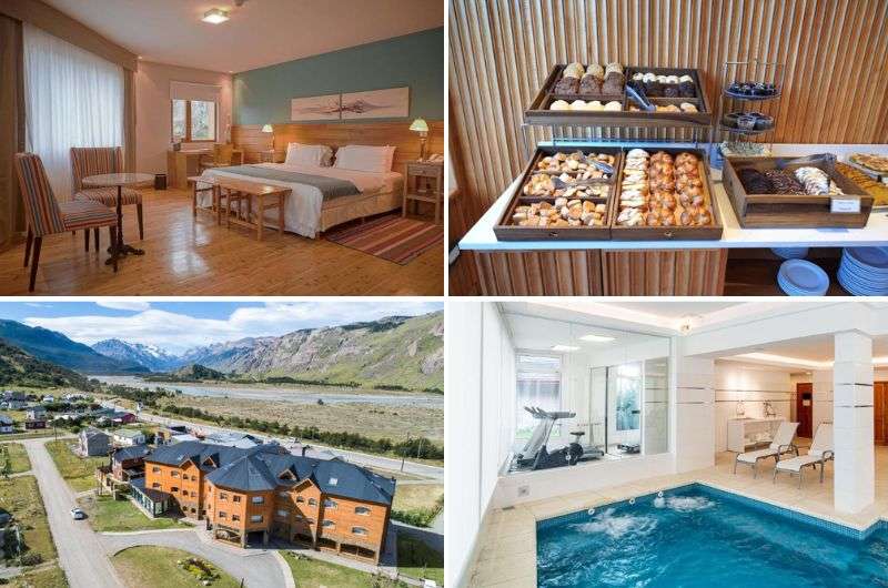
Good hotels are sparse, so book in advance. My picks: the 4* Destino Sur Hotel & Spa de Montaña in El Chaltén and 5* Hotel Imago in El Calafate. Both decent, some aspects of them are fantastic, some, like the breakfast in El Calafate, not so much.
Day 1 of Patagonia itinerary: Arrival in El Calafate and drive to El Chaltén
Today will be a lot about travel and a little about hiking, so do everything in your power to get at least a couple of kilometers in. A day in Patagonia without hiking is like trying to slow dance without a partner—utterly pointless and a bit sad.
Day 1, step 1: Arriving in El Calafate
Your Patagonia adventure begins as you touch down at El Calafate Airport (full name: Aeropuerto Internacional Comandante Armando Tola de El Calafate), likely after a 3-hour flight from Buenos Aires.
Get in as early as possible, there’s no time to waste when you have Los Glaciares National Park on your doorstep! Take the huge distances in Argentina into consideration; if you’re flying in from somewhere other than Buenos Aires, you’ll likely still have a connection in Buenos Aires, so your flight time can easily double to 6+ hours if you’re coming from, say, Iguazu Falls.
Day 1, step 2: Getting to El Chaltén
Anyone who has read any of my articles knows that my favorite way to get around a destination is by car
Next, it’s time to decide how you’ll get to El Chaltén—will you rent a car or take the shuttle? Actually, that would be stupid—make this decision while you’re still at home. We rented a car, I want to say I would take the shuttle next time around, but I think I’d end up renting a car again anyway. Old dogs and their tricks, am I right?
El Chaltén is about a 2-hour drive from El Calafate Airport. You have a couple of options for making the trip:
- Rent a car: If you’re feeling the need for some freedom and flexibility, renting a car is your best bet. But be warned, car rentals can be pretty pricey thanks to the blue dollar craziness. If you’re like me and enjoy the autonomy of driving (not to mention my neurotic tendencies about public transport), this might be the way to go. There are several rental companies at the airport, so take your pick.
- Shuttle service or taxi: For those who want to relax and not worry about navigating the one road, haha, a shuttle service is a fantastic alternative. They’re straightforward, with kiosks right at the airport waiting for the few daily flights. Plus, hiking in El Chaltén is quite compact, so you won’t need a car once you’re there. Personally, in my dreams, I’d take the shuttle—but in reality, I always end up renting a car.
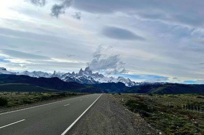
Once you’ve sorted your transport, hit the road for an easy 2-hour or less scenic drive to El Chaltén. The route is paved and offers stunning views, setting the tone for the natural beauty you’ll experience over the next week. The journey itself is part of the adventure, with vast pampas, distant mountains, and the promise of incredible hikes ahead.
Day 1, step 3: Check into your hotel: Destino Sur Hotel & Spa de Montaña
Amazing Destino Sur Hotel & Spa de Montaña!
Check into your hotel… quickly, you can still squeeze in a hike in El Chaltén!
There are a lot of hit and miss hotels in El Chaltén, so make sure to choose a decent one. I went for the 4-star Destino Sur Hotel & Spa de Montaña and it’s a gem—it even doubles as a blue dollar exchange if you’re in a pinch. The rooms are gorgeous and brand new, practically sparkling. The reception staff actually speaks decent English, a rare find in these parts.
You’ll be glad to be able to crash in the hotel’s super comfy beds with top-notch bedding, but not yet! Hold off until later tonight! Someone put real thought into the blackout curtains, a lifesaver in a place where it’s light out until 1 am. The bed is reasonably large—perfect for sprawling out after a day of hiking.
The spa is open until 10 pm, so you can soak your weary muscles to your heart’s content.
The internet works moderately well.
End of report.
Day 1, stop 4: Hike to Mirador de los Cóndores
Mirado de las Águilas
This could be all you have in you for the day, especially if you flew in later than would be ideal, but that would be—in my humble opinion—a complete waste of daylight. You only have 3 full days in El Chaltén, and even with just a couple of hours of daylight left today, you can still smash out some quality outdoor time.
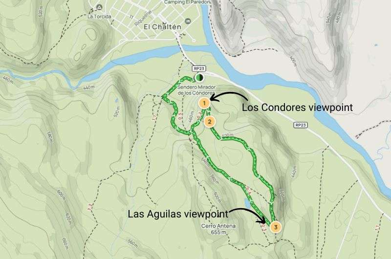
To stretch your legs after the journey, embark on a simple yet rewarding hike to Mirador de los Cóndores.
Hike length: 5.3 km (3.3 mi) loop (or shorter if just going to the viewpoint and back)
Elevation Gain: 215 m (705 ft)
Difficulty level: Easy
Hiking time: 1-2 hours
Trailhead: Starts from the visitor center at the entrance of El Chaltén
Map and details of this hike on Alltrails
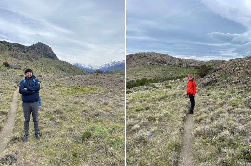
Mirador de los Cóndores is the perfect warm-up hike to kick off your El Chaltén hiking adventure. This short trail takes you to a viewpoint with panoramic vistas of the town, the Río de las Vueltas valley, and the impressive Fitz Roy massif. Keep an eye out for Andean condors soaring above—it’s a sight that truly captures the wild spirit of Patagonia.
Starting from the visitor’s center in the south of the city, you’ll head up to two viewpoints: first, you reach the Mirador de los Cóndores and, continuing along a stretch with just a little more elevation, you get to Mirador de las Águilas.
They got their names because it is possible to appreciate the eagles and condors flying overhead at both. They also offer unique views of Cerro Torre, Mount Fitz Roy, its glaciers on one side, and El Chaltén, Lake Viedma, and the Patagonian steppe on the other.
Tip: A lot of people complain about the trail not being properly marked—there aren’t many signs, I can agree with that. But honestly, it’s quite obvious where the path is. There's nowhere else to go, and it’s mostly plain with no trees, so you can see the trail or at least guess where you should walk.
The trail kicks off from the visitor center with a steady incline. This section is slightly steeper, but nothing you can't handle even after surviving a flight and a drive. As you walk, the views get progressively more stunning. You’ll soon realize why this place is called the "Hiker’s paradise". The first viewpoint, Mirador de los Cóndores, is a mere 1.5 km (1 mi) into the hike. From here, you can see El Chaltén laid out below you like a tiny toy town, with the mighty Fitz Roy looming in the background.
Then, continue to Mirador de las Águilas. The additional stretch is only a little over 1.5 km (1 mi) further with only a little more elevation, so you’re already done most of the work. Overall, I’d say it’s an easy trail if you're used to hiking or if you're in good condition. Wear good shoes, take some water, and maybe a light jacket—it can get windy up there!
Note: In the mornings, up until lunchtime, the trail will be bustling with tour groups, but since you’re tackling this in the afternoon, you should have a much calmer experience. But even if the trail looks busy, I can almost promise that once you reach the Condor Lookout, everyone turns back, so after this point, it’ll probably be just you and the Andean wind.
Get a good night’s rest because tomorrow, you’ll be going on one of my favorite hikes in Patagonia: the hike to Laguna Torre.
Day 2 of Patagonia itinerary: Laguna Torre hike
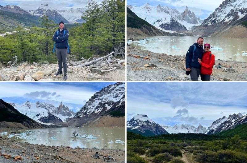
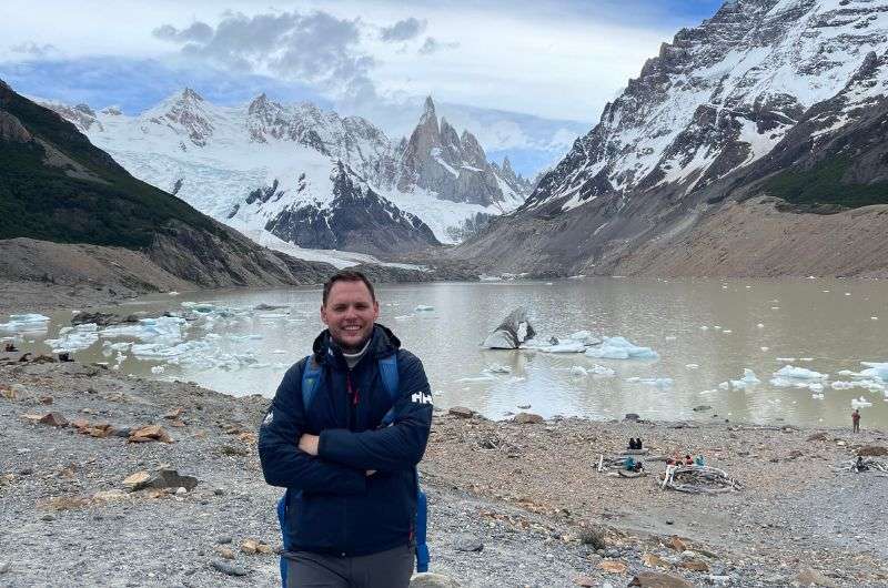
The Laguna Torre hike keeps delivering views!
Welcome to Day 2 of your Patagonia adventure—it’s time to tackle the Laguna Torre hike! Think of it as a warm-up hike, since it is pretty long, but also very moderate, so you won’t wear yourself out on the very first day in Los Glaciares National Park. Now that would be an epic fail.
Hike length: 17.5 km (10.9 mi), out & back
Elevation gain: 501 m (1,643 ft)
Difficulty level: Moderate
Hiking time: 5 hours
Trailhead: Google Maps link to trailhead
Beautiful trail in the Rio Fitz Roi river (see the map on Alltrails)
Before you even think about hitting the trail, gear up properly. Patagonia’s weather is about as predictable as a cat on catnip. You might wake up to clear blue skies, but that can change faster than you can say "Laguna Torre". So, don’t be tempted to leave your jacket in your hotel room.
Here’s your essential packing list:
- Sun protection: Sunscreen, sunglasses, and a hat. The sun here can be brutal. I know, because I’m a fool that got brutally sunburnt in Patagonia!
- Wind protection: A good windbreaker—it’s Patagonia, folks!
- Snow protection: Yes, even in the summer. You just never know.
- Layered clothing: Dress in layers so you can adjust to changing weather.
- Water and snacks: It’s a long hike, stay hydrated and fueled.
Start your hike from the trailhead in El Chaltén, which is very convenient, since you don’t need a car or taxi to get there. The beginning of the hike is where you’ll encounter the main climb—about 175 m (570 ft) of elevation gain right off the bat. It’s a bit of a workout, but once you’ve conquered that, the trail levels out and becomes much easier. Like I said, this hike’s moderate rating is due more to the length than anything else.
After the initial climb you’ll reach Mirador Margarita. From here, the views are stunning, especially of Cerro Torre and the Margarita Waterfall. Beyond that, the path isn’t too demanding, but expect some climbs until you reach Laguna Torre.
The trail is variable enough to stay interesting, but it never gets too exciting, if you know what I mean. A lot of easy-to-follow paths, with some rockier areas, and, if it had been raining recently, you’ll probably run into a muddy pools on the trail. Nothing serious though, and you’ll do fine walking the trail even in trainers. Keep your eyes peeled for wildlife—condors often soar overhead, and you might spot a guanaco or two. About halfway through, you’ll reach a stunning viewpoint over the Fitz Roy River valley. This is a great spot for a quick snack and some photos.
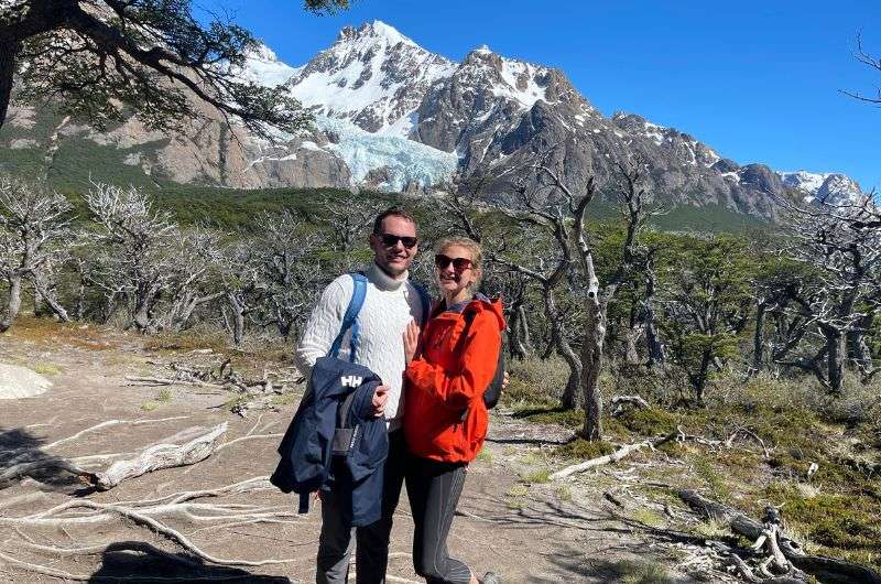
Me and my girlfriend hiking the Laguna Torre hike
After a few more kilometers, you’ll arrive at Laguna Torre. The lake is fed by the Torre Glacier, and the towering spires of Cerro Torre create a dramatic backdrop. If the weather’s clear, you’ll get an incredible view of these iconic peaks reflected in the glacial waters… unless the clouds are covering everything. If they are, don’t give up and leave! Clouds have a reputation of moving around you know! And with the wind the Laguna Torre trail gets, it’s just a matter of how fast. We waited, and were rewarded with some fantastic views of the peaks, unlike some others we saw just call it a cloudy day and head back without reaping all the benefits. Bad decision, guys, bad decision!
Fun fact: Cerro Torre is one of the most challenging mountains to climb in the world. Just looking at it will give you chills (and not just from the cold).
Tip: Don’t be tempted to turn back without reaching the viewpoint at the very end. You may feel like you’ve seen it all before you get there, but you’d be wrong. Make the loop anti-clockwise to get the most out of the views. Beware there are lots of loose rocks in this last part.
The return journey is the same trail back, so you’ll get to enjoy the views from a different perspective. The descent is generally easier, but trekking poles can be really handy for the last descent.
Day 3 of Patagonia itinerary: Laguna de los Tres hike
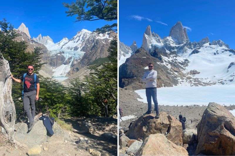
Non-stop incredible views on Laguna de las Terres hike
If you haven’t gushed over how incredibly lucky you are to be able to see the Los Glaciares NP scenery with your own eyes, you will today. You’ll tackle the legendary Laguna de los Tres hike, one of the absolute best treks in El Chaltén—I think so, the world thinks so, and now you will too.
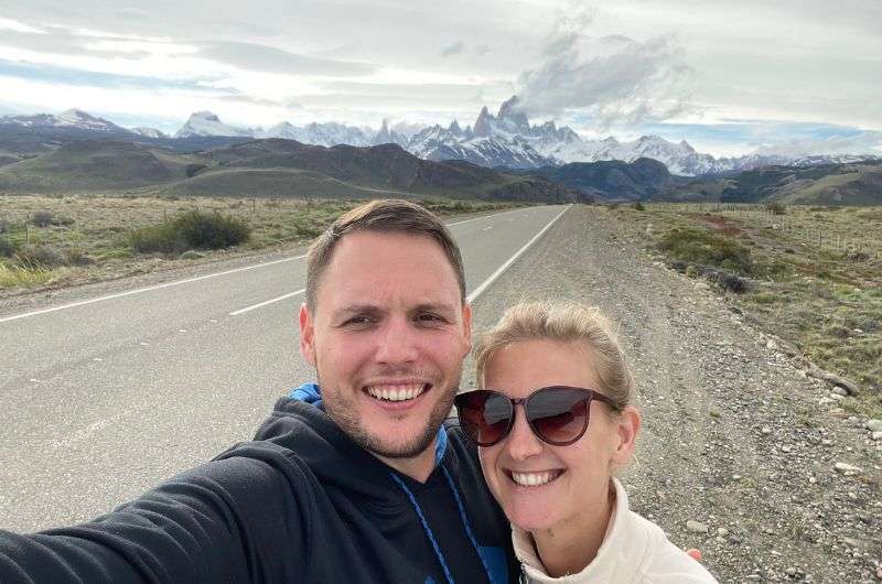
This trail offers some of the most spectacular views in all of Patagonia, including the iconic Mount Fitz Roy that’ll be in front of you for the entire first half of the hike (because then you turn back and go the same way you got there on). It’s a challenging yet incredibly rewarding hike that will leave you in awe of nature.
Before we start, let me just say—El Pilar Valley (which is the one you’ll be walking through) is perhaps the most beautiful sight I’ve ever seen. It's a wide valley with a river, surrounded by enormous, glacier-covered mountains. You can even hear the thunderous sound of falling ice—if you’re lucky. It’s also possible to reach Laguna de los Tres from the El Chalten side, but the El Pilar Valley is a place you simply cannot miss.
Beautiful mountain massifs along the valley, my lovely girlfriend and handsome me
I prefer starting on this side also because gives you a much gentler and more photogenic end to the trek. In contrast, starting from El Chaltén involves a fairly steep descent at the end. And not but not least, starting from El Pilar, you'll encounter very few people compared to El Chaltén, and the views are significantly better in my opinion.
Hike length: 21.9 km (13.6 mi), out & back
Elevation gain: 1,000 m (3,280 ft)
Difficulty level: Hard
Hiking time: 8 hours
Trailhead: Google Maps link to trailhead
Map and details of the Laguna de los Tres hike on Alltrails
My top tips for the Laguna de los Tres hike:
- Start from the top: Start your hike on the El Pilar side, not in El Chaten. The trek is much better, with better views, and less crowded on this side.
- Drinkable water: The water around this area is drinkable, so make sure to bring a refillable bottle.
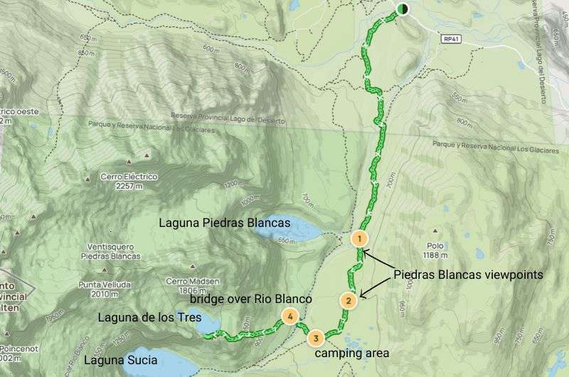
- It’s not just one laguna! Keep your eyes peeled and camera ready before reaching the end of this hike, because Laguna Piedras Blancas is clearly there to steal a big chunk of your attention.
- Must-visit add-on: And don’t stop right when you reach Laguna de los Tres, either—definitely take a detour to the viewpoint over Laguna Sucia. It's about 500 m (0.3 mi) along the lake to the left. The views there are dramatically more stunning!
Again, it’s important to remember that the Patagonian weather is a fickle beast. Then head to the trailhead… which one? The one that matches the hike by name is on Google Maps as Sendero Laguna De Los Tres, the other is just a little closer to El Chaltén and is the El Pilar trail. It doesn’t matter which you choose because they converge after the initial section.
Start early, ideally before 9 am, to avoid the crowds and increase your chances of calm, wind-free conditions at the lagoon. The trail is well-marked, much like in the USA, so you can’t really get lost. Argentina did a great job with this one!
Starting from El Pilar, you'll encounter very few people compared to El Chaltén, and the views are significantly better. The auto strikes again! I highly recommend hiking from El Pilar and back. It's a much gentler and more photogenic end to the trek. In contrast, starting from El Chaltén involves a fairly steep descent at the end.
The first part of the hike involves a steady ascent. For the first 3.5 km (2.1 mi), you’ll gain about 300 meters in elevation. The climb is a bit of a workout, but the dramatic views make it worth every step. Think of it as entering Middle Earth, with ice, snow, and towering 3,000 m (9,800 ft) walls surrounding you.
After the initial climb, the trail levels out, and you’ll pass by smaller waterfalls and lakes. Notably, you’ll pass by Laguna Piedras Blancas, a stunning lake with crystal-clear, icy blue waters with the imposing Fitz Roy in the background. You’ll want to have your camera out for these views!
About 5 km in, you’ll reach a fork: go left to continue towards Laguna de los Tres.
You know how they say, the calm before the storm? Well, the middle section is the flat before death. The last part will test your physical fitness and agility on unstable terrain. There’s a steep, rocky climb waiting for you. We met an older couple on the trail who had to turn back in the last section because they just didn’t have the energy left.
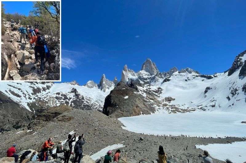
The last part of the Laguna de las Torres hike is steep! “Luckily”, you’ll have a lot of people there to help you if you need assistance
But once you get up there, you’ll get to take in the sight of Laguna de los Tres, nestled at the base of Mount Fitz Roy. The laguna is often dotted with icebergs, adding to the beautiful scenery. The laguna looks like it’s straight out of a fairy tale, and you half expect an evil queen to send a hero to rescue a princess from its icy depths. It’s that magical!
Take your time to soak in the views. If you’re lucky and started early, you might experience the rare calm without the typical Patagonian winds. Have your packed lunch by the laguna, snap a ton of photos, and just bask in the magnificence of it all. Since it’s an out-and-back trail, remember that every step you take up, you’ll have to take down. I found the descent through the last passage tougher than the climb.
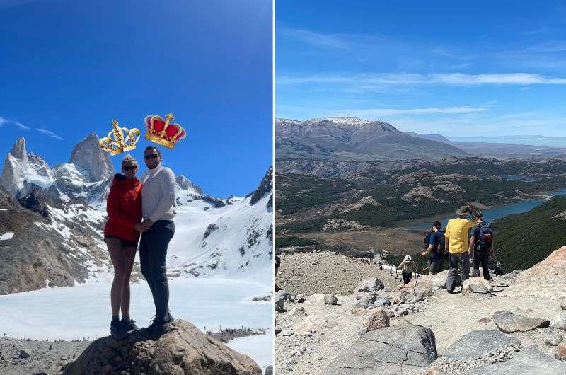
I must say, after conquering the Laguna de Lost Tres hike we felt really good about ourselves
If you can handle some more dramatic views, I strongly recommend you take a 500 m (0.3 mi) detour to the Mirador Laguna Sucia, a viewpoint that gives you a peak at the next lagoon. The views there are dramatically more stunning!
Tip for the mighty: If 22 km isn’t enough for you and you’d love to not have to walk back the same way, there is a trail from Laguna de los Tres all the back to El Chaltén. Check Alltrails for details on that route.
Day 4 of Patagonia itinerary: Whitewater rafting, hike to Laguna Azul and Laguna Verde
Today will be a very sporty day... the beginning is mild and then all watery hell breaks loose!
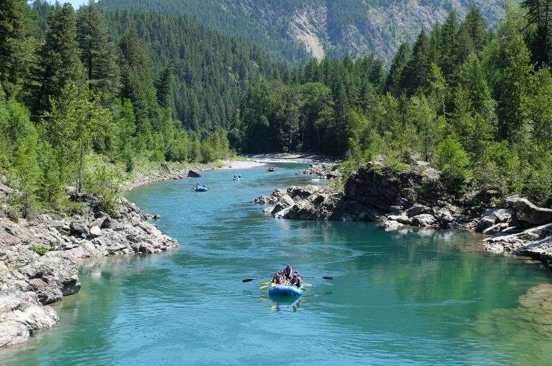
Day 4, stop 1: Whitewater rafting on Río de las Vueltas
Ok, it’s time to shake things up a bit and add another activity to all the hiking you’re doing in El Chaltén. It’s a great adrenaline rush and you can sit the entire time—I’m talking about whitewater rafting on Río de las Vueltas! It’s the perfect combination of tranquil sections and wild rapids for thrill-seekers.
Rafting details:
River: Río de las Vueltas
Distance: 16 km (10 miles)
Duration: 2 hours on the water + 1 hour getting there, instructions, gearing up etc.
Difficulty: Varies from beginner-friendly calm sections to exciting rapids
Gear Provided: Dry suits, life vests, helmets
I recommend Comarca Expediciones. Their rafting trips take about 3 hours total (with 2 hours on the water) and cost USD 120 (which is only about USD 40 after blue dollar exchange rates!). They have 10 am and 2:30 pm time slots each day, and the morning one is perfect for this day on your Patagonia itinerary; you’ll even have some time to sleep in a little!

RÍo de Las Vueltas is calling!
You start by gearing up in your dry suits, life vests, and helmets. Safety first, folks! Once everyone is suited up, you’ll get some initial practice and instructions on the calmer part of the river. For the first 6 km or so, it’s a lovely little paddle. This is a great time to relax and take in the stunning scenery, including glimpses of the majestic Cerro Fitz Roy. Our guide was fantastic, full of energy, super knowledgeable, and great at pointing out interesting sights along the way.
Tip: Keep your eyes peeled for the wildlife you might spot along the way—condors, llamas, and even some lambs. Later in the rafting session, you’ll be too busy holding on the dear life to notice them.
Then comes the fun part: the rapids! Your guide will shout out instructions, and you'll need to paddle like crazy to navigate the waves. Sitting at the front? Get ready to be soaked—the first splash is a wake-up call, and remember, this water is straight from the glacier. It’s cold, but man, is it exhilarating!
After the ride, you’ll get to warm up with some coffee and a pastry. It’s a perfect way to wind down and share stories with your rafting buddies. You know, if you enjoy talking to strangers.
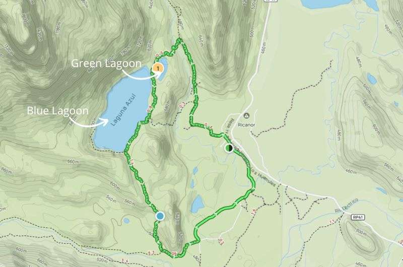
Day 4, stop 2: Hike in Los Huemules to Laguna Azul and Laguna Verde
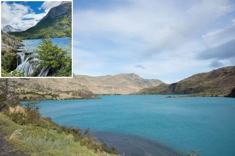
Laguna Azul aka the Blue Lagoon—no need to explain the name
After drying off and warming up (and grabbing a quick lunch), it’s time to lace up those hiking boots for another adventure. Today’s 2-hour hike takes you through the landscapes of the private Estancia Los Huemules Reserve to Laguna Verde and Laguna Azul. Be there by 3 pm! This is a private reserve and it closes at 6 pm, and they don’t let anyone in past 3 pm.
Distance: 8.0 km (5 miles) loop (there’s a much shorter route available, too)
Elevation Gain: 220 m (722 ft)
Difficulty: Easy
Hiking time: 2 hours
Trailhead: Los Huemules Visitor Center
Price: Permit required, ARS 19,000 (USD 20) per person (book online in advance)
Opening hours: 9 am–6 pm, last entry at 3 pm!
Get full hike details on Alltrails
Start your hike from the Los Huemules Visitor Center, where you’ll need to register. You have to pay for your permit online in advance, so do that on the Los Huemles official website. This is both the starting and ending point of the hike.
The trail follows a path parallel to the Diablo River. You’ll cross the river via a suspension bridge, adding a touch of adventure right from the get-go. You can reminisce about whitewater rafting as you walk over the river.
As you continue, you’ll first reach Laguna Verde, which means Green Lagoon. I swear the water is black, but my girlfriend clearly saw green hues… must be my man eyes. It’s the smaller lagoon of the two. From here, the trail leads you in just a few minutes to Laguna Azul, aka Blue Lagoon. Now here is where we could agree on the color—it was the best indigo I’ve ever seen! Bonus points for a beautiful glacial waterfall.
The return journey takes you through a beautiful forest. The landscapes are pretty, with privileged views of Cerro Aniversario and the snow-capped peaks accompanying you all the way. Patagonia, eh?
The hike is well-marked and straightforward. You should be able to walk the entire loop within 2 hours, no problem. You can even skip the forest section and do just about a third of the length in a much smaller loop to just the lakes.
Wildlife warning: Keep an eye out for huemules (South Andean deer), foxes, and a variety of birds!
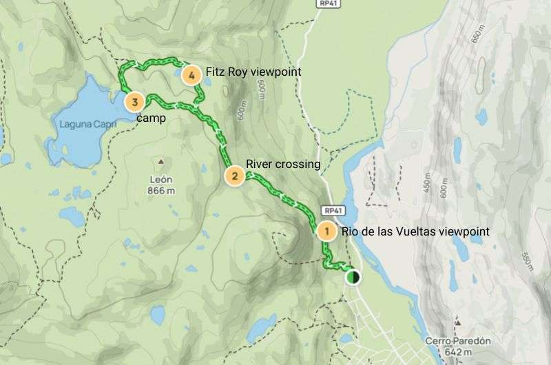
Day 5 of Patagonia itinerary: Hike to Laguna Capri, drive to El Calafate
Today is your last chance to hike up a storm in El Chaltén, because you’re driving back to El Calafate in the afternoon. And if you’re anything like me, you’ll be leaving wishing you had more time!
Day 5, stop 1: Laguna Capri hike
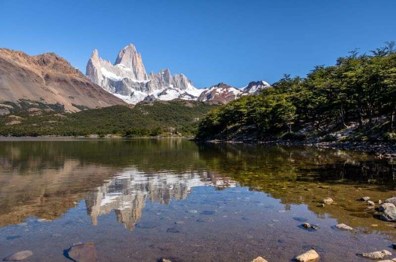
Laguna Capri with Mr. Fitz Roy in the background
After 3.5 days of treks in El Chaltén, it's time to bid farewell to this part of Los Glaciares National Park. And what better way to do that than with a hike to an amazing Fitz Roy viewpoint and another laguna—no, you cannot see too many lagoons in Patagonia. This is a moderate hike at the worst, and unless you’re doing this in the snow, you can easily do this hike in trail runners or similar.
Hike length: 9.5 km (5.9 miles) round trip
Elevation gain: 430 m(1,411 ft)
Difficulty level: Moderate (don’t believe the Alltrails “hard” rating!)
Hiking time: 3 hours
Trailhead: End of Avenida San Martín, El Chaltén
Laguna Capri hike, map and details on Alltrails
The hike kicks off with a bit of a workout. The first 2.5 km (1.5 mi) are mostly uphill, but already after the first km you’ll have reached the "Mirador Río De las Vueltas”, a natural viewpoint offering magnificent views of the river valley below. The trail follows the "Senda al Fitz Roy" path until you reach the well-marked turn-off for Laguna Capri on the left, about 3 km (1.8 mi) in.
After the initial climb, the trail winds through forests of native lenga and ñire trees. This section of the hike is less strenuous and offers plenty of opportunities to appreciate the local flora and fauna, aka, take a breather and pretend you’re interested in trees and birds.
Soon, you’ll reach the shores of Laguna Capri. The sight of the lake with the towering peaks of Cerro Fitz Roy in the background is absolutely stunning. There are small sandy beaches along the shore where you can relax a bit and the Laguna Capri campground if you need a bathroom break or a beverage. Bring a light picnic and enjoy it by the water. The views here are unbeatable and your Instagram followers will thank you.
At Laguna Capri, you’ll continue going on a roughly 2 km (1.2 mi) loop that I certainly don’t advise skipping. This loop takes you to the Mirador Fitz Roy, offering one of the best views of the iconic mountain. Just like the lagoons here, you can’t get enough views of Fitz Roy. He’s magnificent! You don’t have to add this last bit, but it's a short detour that rewards you with a panoramic perspective that you won't want to miss.
The return journey is the same route back. The downhill sections make the hike back to El Chaltén easier and faster, though your knees might be thinking otherwise. The descent is much quicker, mainly because gravity is your friend now.
Note: This trail can be extended all the way to Laguna de los Tres, so if you keep seeing people coming from another direction, you now know where they’re coming from.
Back at the bottom, pile into the car and start your drive back to El Calafate.
Day 5, stop 2: Drive to El Calafate
The road through El Calafate
The drive to El Calafate from El Chaltén is around 2 hours, but at this point in your Patagonia adventure it feels a little like a transition from a Tolkien novel back to reality. Use this time to reminisce about the previous days’ adventures, sift through the countless photos, and maybe catch a nap—just not if you're doing the driving.
Day 5, stop 3: Check into your hotel: Imago Hotel & Spa
By the time you roll into El Calafate, you'll be ready for some R&R. Tomorrow, we tackle Perito Moreno, but for now, sleep like a log—or a tired hiker who’s made a deal with the devil and come out victorious.
We stayed at Imago Hotel & Spa and I can recommend it. The room was fantastic, and after a day of hiking, that’s exactly what you need—a great night’s sleep. The spa was also a highlight with a super warm pool, which must have cost a fortune to maintain. Another plus was the excellent location closer to Perito Moreno, so no need to drive across town. The Wi-Fi in the room was fast enough for streaming, so no complaints there, either.
Now, the downside: The breakfasts were atrocious, and I really love a good breakfast, so you can imagine my face after eating my toast and eggs. The worst part is, there’s no point in trying to find a better breakfast at a nearby restaurant because it’d probably be just as tragic as the one at the hotel.
Day 6: Perito Moreno—walk, kayak, and learn!
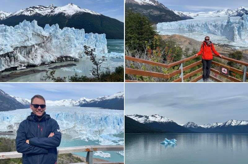
The ultimate glacier experience—Perito Moreno Glacier hike
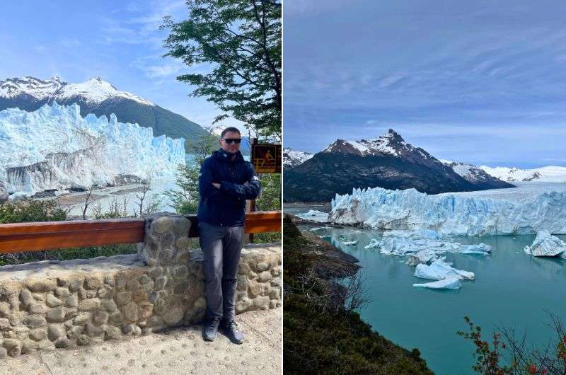
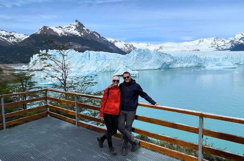
Today’s experiences are the type you don’t want to miss—you’ll understand exactly why you had to leave El Chaltén after you see this! Perito Moreno Glacier is the icy superstar of Patagonia, the most famous glacier in Los Glaciares National Park, and you have the opportunity to not only see it, but also to go kayaking right by it. Seriously, can you think of a better place to kayak than right in front of a 60 m (197 ft) high glacier wall? Exactly, you can't.
Perito Moreno facts: This behemoth of ice is not only massive but also unique in that it’s one of the few glaciers in the world that is still growing. The terminus of the glacier is a whopping 5 km (3.1 mi) wide, with an average height of over 70 m (240 ft) above the surface of Lake Argentino. And that’s just what you see above water—the total ice depth goes down to a staggering 170 m (558 ft)! What makes Perito Moreno even more special is that it periodically advances across the lake to block the Brazo Rico channel, creating a natural dam and causing a spectacular rupture when the water pressure becomes too great.
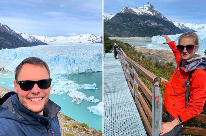
Day 6, stop 1: The walkways at Perito Moreno
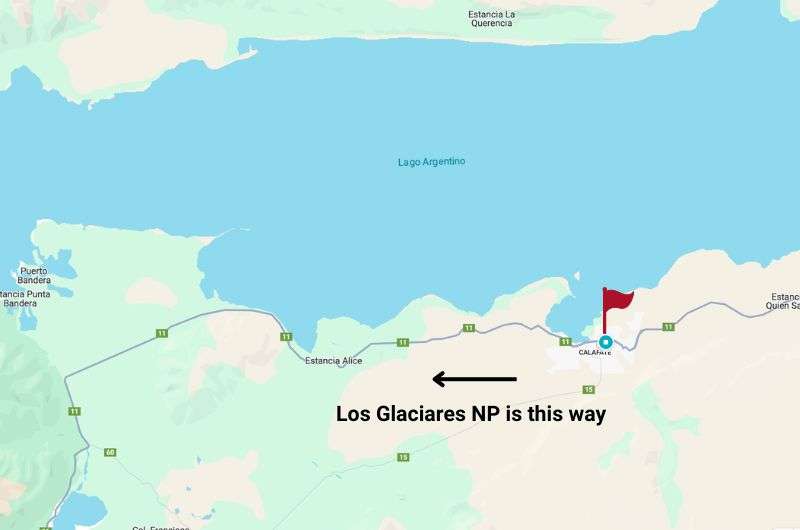
El Calafate city is close to Los Glaciares National Park
First of all, be sure to consider the time it will take you to drive from Imago hotel to the glacier—it's about 73 km (45 mi), which will take about an hour. A little more if you stop at the viewpoints before reaching the parking lot at the end.
You park at the parking lot and then either hop on the shuttle bus or walk the rest of the way like we did if you really want to earn those views. Dish out ARS 30,000 (USD 30) for entrance and be prepared to be wowed. You'll immediately feel the ice cold air coming from the glacier. The visitor center will give you all the information you need, you’ll get a map, and there’s no need to book anything else except for the kayaking (your next activity).
The wood + steel pathways are designed to make you feel like you’re walking on the glacier itself (without the whole freezing your toes off part—you'll see tomorrow!). These walkways stretch out over 4.5 km (2.7 mi) and provide multiple jaw-dropping angles of this massive ice beast. The walkways at Perito Moreno are color-coded, so even if you’ve had one too many Argentine wines the night before, you won’t get lost. The red and blue trails are the best. There are plenty of benches along the way to park yourself and just soak in the frosty goodness.
We couldn't get enough of the glacier views
From the elevated platforms, you get to see just how monstrous this thing really is. The sight will stop you in your tracks. The mountains around it are 3000 m high, and the glacier itself is incredibly straight and beautifully cracked. It’s like Iguazu Falls but in reverse!
The little icebergs and pieces of ice floating around significantly add to the dramatic scenery, since compared to them, Perito Moreno’s size stands out even more.
Another amazing thing to see are the boats near the glacier. They look like tiny toys next to this massive wall of ice. But the most exciting thing you can witness is giant ice blocks breaking off the glacier. It’s indescribable how loud it is when it happens—deafening! This is how I imagine a bomb going off sounding like. We certainly turned into falling ice hunters, because it happens fast and only once in a long while.
It’s a good idea to bring some water and light snacks, especially if you plan to spend hours here (and you will). But there’s also a restaurant with giant glass windows and epic views up by the parking lot if you want to go warm up for a bit and eat something warm.
Day 6, stop 2: Kayaking or boat trip at Perito Moreno
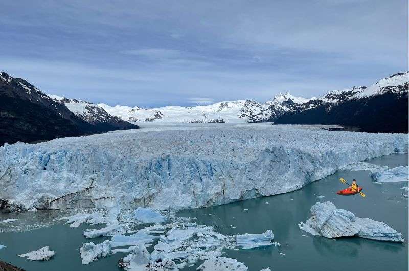
Find the kayak! @ Perito Moreno
Next up is the exhilarating part of your 6th day in Patagonia. You can either book a tour in advance with an agency, but in my opinion, it's much better to sort it out once you're there. Just stop by the visitor center and book your time.
Even if it's your first time kayaking, don't stress. The guides will explain everything and give you all the instructions you need, plus they’ll be with you the entire time. They’ll take about a trillion photos of you and provide some interesting info about the glacier. You’ll spend around 1.5 hours in the kayak, which is just the right amount of time.
I’m telling you, you’ve never felt so small as when you're in a tiny kayak paddling beneath a massive—really massive!—glacier. It’s the best perspective from which to observe the glacier. Sure, you’ve seen it from the walkways and on about a bazillion photos up until now, but it’s not until you get up close and personal that it really hits you—I say this figuratively, not literally! That would be too personal.
Tip: The most thrilling part is seeing and, more importantly, hearing the cracking and falling chunks of ice with your own eyes and ears. It's totally dramatic and cool.
Alternative: boat trip by the glacier
If kayaking seems a bit too adrenaline-filled for you but you still want to get close to the glaciers, then a boat trip might be the perfect solution. You'll feel safer in a larger boat but still get the chance to see the glaciers up close. Sissy.
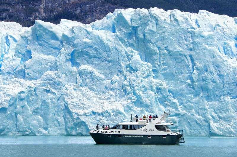
Boat trips are a less adrenaline-filled variant to see the glaciers close-up
Just keep in mind that if you book the trip in advance, it’ll be one of those typical organized tours. They’ll pick you up from your hotel in the morning, and what should be a half-hour trip will take an hour because they’ll be picking up another 20 people. They’ll pack the boat as full as possible, so you might not even get close to the edge for good photos. So, my classic advice is, if you're going for a boat trip, book it on the spot to spend the least amount of time in the madness.
Day 6, stop 3: Glaciarium Patagonian Ice Museum
Ok, that’s enough adrenaline for one day. Next, drive back to El Calafate, and right before you hit town, turn off to the Glaciarium Ice Musem. A laid-back, educational stop for you in the form of a museum. I just can’t resist a good museum. The Glaciarium is a glacier interpretation center. Its goal is to educate people about ice, glaciers, and especially the Southern Patagonian Ice Field. For a bit of perspective, the Southern Patagonian Ice Field covers over 13,000 km² (5,000 mi²) of glaciers and is one of the largest ice expanses outside of Antarctica.
The museum opened in 2011, so it’s quite modern, and the whole exhibition is designed to be engaging, even if you’re not a huge fan of museums. You’ll learn all sorts of interesting stuff, like how ice forms and how glaciers move and shape the landscape. It’s the perfect place to go after seeing, hiking, and hearing the glaciers in real life.
Plus, there’s the Glaciobar—a bar made entirely of ice. You can only enter it wearing a poncho, gloves, and special shoes, and you can stay for a maximum of 20 minutes because it’s just that cold in there.
The Glaciarium is open 12 pm–7 pm every day and tickets cost ARS 18,000 (USD 20).
Day 7: Ice walk/Ice climb in Perito Moreno
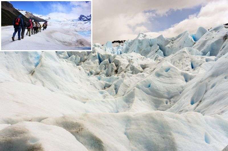
Ready to walk on this??
This is your last day in Patagonia, the land of incredible glaciers. Perito Moreno is like the poster child of Los Glaciares National Park, so it’s only fitting that you go walk on that thing! Didn’t think you could, did you?
I, sadly, couldn’t it a smidgen more time into Patagonia and couldn’t go on a Perito Moreno trek, having to make do with just the walkways and kayaking. But you can and should do more! Here’s the info:
Glacier treks on Perito Moreno are done by Hielo&Aventura and are an all-day adventure. They pick you up in El Calafate, give you 1 hour for the walkways first before taking you on a boat for about 20 minutes to a spot where you can walk onto the ice. How exhilarating is that?! There are different options, some are harder, some a little easier, but it’s always walking with crampons on uneven, icy terrain for about 3 hours. The harder treks have you walk first through forests before you reach another area that is the hardest difficulty. If you add all the transfer times, you’re looking at 9–12 hours from start to finish.
Prices are from ARS 210,000 (USD 220) for the shorter tours to ARS 400,000 (USD 440,000) for the long program.
Trekking on Perito Moreno is more than just an activity—it’s a story you'll be telling for years. It’s the perfect blend of challenge and beauty, offering a unique way to experience one of Patagonia’s most iconic landmarks. Tell me about it if you go!
I have about 16,000 photos with this thing, it’s just incredible
Day 8: Departure
I could just end the article there, you already have the perfect 7-day Patagonia itinerary, after all, but that wouldn’t be my style. I’m a little OCD about researching complete information before any of my trips, and I like to make that easier for my readers by just giving you every bit of travel information and advice in one spot, just like I wish someone had done for me.
So, here we go with the FAQ portion of the article:
FAQ 1: Why is Los Glaciares National Park famous?
Los Glaciares National Park is renowned for its stunning glaciers, vast lakes, and impressive mountain scenery. Interestingly, glaciers usually form at altitudes of 2,500 m (8,200 ft) above sea level or higher, but here in Los Glaciares, they form on the ice fields at 1,500 m (4,920 ft) and flow down to 200 m (656 ft). What that means is that unlike other places where you have to be a hardcore mountaineer to see glaciers, in Los Glaciares, they’re right there at eye level! Even grandma can join the fun.
It’s such a special place to visit—I mean, how many times in your lifetime do you get the chance to visit a national park with 47 giant glaciers and another 200 smaller ones?!
You bet it is a worth visiting!
Now, let me describe all 47 large glaciers to you. Just kidding, I’ll only tell you about the most famous ones:
- Perito Moreno Glacier: You've probably heard of Perito Moreno Glacier before, even if you’re not particularly interested in Patagonia, hiking, or glaciers. It’s an A+ celebrity in Patagonia and a total giant. For perspective, the front of the glacier rises over 50 m (165 ft) above the water at its highest point. What’s most fascinating about this glacier is that it moves and shifts, and huge chunks of ice break off from it. That’s something you definitely want to see.
- Upsala Glacier: This is the largest glacier in Los Glaciares National Park, covering 765 km² (295 mi²), and is located near Lago Argentino.
- Spegazzini Glacier: This glacier is famous for its towering walls, reaching up to 135 meters above the lake’s surface.
- Viedma Glacier: Known mainly for its glacial caves that tourists can explore.
Besides glaciers, Los Glaciares National Park also boasts two significant lakes formed (surprisingly) by glacial melt: Lago Argentino, which is the largest lake in Argentina, and Lago Viedma.
It’s probably no surprise that this area is a UNESCO World Heritage site, having been added to the list back in 1981.
Can’t get enough of Perito Moreno!
FAQ 2: How many days do you need for El Calafate?
It depends on how hardcore of a tourist you are, but I’d say a minimum of 3 days. In 3 days, you can visit Perito Moreno Glacier and squeeze in a few hikes and other experiences. Just to be clear, we're talking about the El Calafate area only. Then, you’ll need at least another 7 days for El Chaltén, at least in an ideal world. Patagonia is an absolutely incredible region that deserves thorough exploration.
FAQ 3: How many days in El Chaltén?
Anything more than 7 days is ideal, but even if you need to split the time between El Chaltén and El Calafate, it’s still a solid amount of days for the region. It depends on how much you want to see and how much stamina you have for hiking and all the activities around. Less than 7 days and you won't see it all, leaving you with this nagging feeling that you missed out and need to return. Fine by me!
It's the exact opposite of Buenos Aires. All the blogs will say you need 5 days, but you can see the interesting stuff in one day. Seriously, read my one-day itinerary in Buenos Aires and you’ll agree with me. For Patagonia though, allot more time rather than less.
FAQ 4: How much is a taxi from El Calafate to El Chaltén?
The taxi fare between El Calafate and El Chaltén is around USD 20–30. That’s pretty cheap considering the journey takes over 2 hours. We rented a car, but next time around I’d just take the shuttle from the airport.
FAQ 5: When to visit El Chaltén?
It's pretty simple: November to April is the best time to visit Los Glaciares National Park. The southern part of Argentina is like Scotland or Norway—chilly and rainy with occasional snow. But hey, you want to see Patagonia as an adventure, so why be bothered by a bit of snow?
My tip: Go in November or April. These months are great for combining with other parts of Argentina or Chile, where it gets extremely hot during the main summer months (December–March). Plus, prices are more affordable during this "shoulder" season. However, El Chaltén was packed with people in November, so…
FAQ 6: How cold does it get in El Chaltén?
The weather in El Chaltén is THIS variable (and yes, I got a sunburn)
In El Chaltén, temperatures can drop to as low as -10 °C (14 °F) in winter (June–August), which is why I wouldn't recommend visiting then. In summer, temperatures range from 10 °C (50 °F) to 20 °C (68 °F), and on sunny days, it can even hit 30 °C (86 °F).
Whenever you go, be prepared for rapidly changing weather. As a true adventurer, you must be ready for anything. Also, it gets very windy on the mountain peaks, so keep that in mind. Sure, El Chaltén is at an elevation of about 400 m (1,300 ft), but the surrounding peaks like Fitz Roy and Cerro Torre reach over 3,000 m (9,850 ft).
FAQ 7: Where to eat in El Chaltén/El Calafate?
I can’t really help you with restaurants. It’s not that we didn’t eat, but none of the restaurants were spectacular, so I’ll leave the choice to you and wish you a better hand. And I'd be happy to take your recommendations if you find something really good. Wherever you go, be prepared for a lot of meat and no veggies. I think I’ll pack some bell peppers next time!
You might also be interested in reading:
The best 2-week itinerary for Argentina
How to plan a trip to Iguazu Falls (3-day plan)
12 epic day hikes in Argentina of all difficulty levels
27 fun facts and travel tips for Argentina
This post contains affiliate links. I earn a small commission if you make bookings through my links, at no additional cost to you. Thank you for your support!


Comments | Thoughts? Give us a shout!