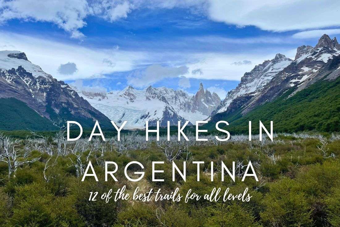
Argentina Hiking: 12 Best Day Hikes for Every Fitness Level

Argentina is an absolute powerhouse for hiking and there’s something for everyone; as much as the mountaineers love conquering the summits, tourists can’t get enough of the day hikes. From my own experience, I’d even go so far as to say that Argentina is a land of shorter hikes. Basically, if you’re wondering where in the world to go for the best, most spectacular day-long hiking trails, pick here.
These are the best day hikes to take in Argentina:
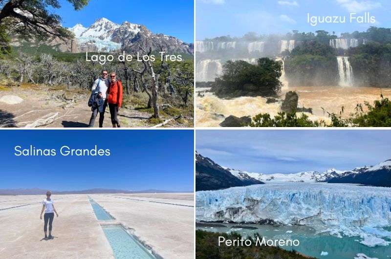
- Iguazú Falls hikes (Misiones)
- Perito Moreno glacier tour (Los Glaciares National Park)
- Laguna Torre, El Chaltén hike (Los Glaciares National Park)
- Los Horcones hike (Mendoza)
- Vinciguerra Glacier trail (Tierra del Fuego)
- Laguna de los Tres, El Chaltén hike (Los Glaciares National Park)
- Los 14 Colores del Hornocal viewpoint trail (Jujuy)
- Valle Encantado trail (Salta)
- Salinas Grandes trail (Salta)
- Quebradas de las Señoritas viewpoint trail (Jujuy)
- Doctor’s Viewpoint, Bariloche hike (Río Negro)
- Cerro Negro hike (Mendoza)
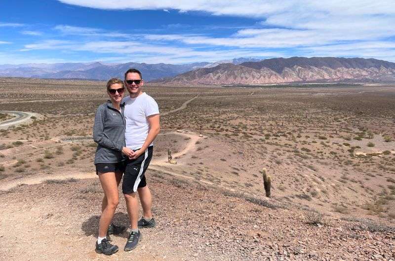
From northern Salta through Bariloche and the Lake District to southern Patagonia, everywhere you look in western Argentina, you’ll see mountains. Within them, you can also see magnificent glaciers such as the Perito Moreno, as well as colorful, out-of-this-world deserts such as the Serranía de Hornocal.
I was even stunned by Iguazu Falls, a spot surprisingly good for hiking, and it just goes to show that Argentina delivers everything without you expecting anything—I expected just to take a few pictures, and instead found places I wouldn't get tired of for days.
What you’ll find in this article
I’ve put together all the information you could need on my 12 favorite day hikes of varying difficulty, in Argentina, including insider tips from my personal experience hiking them. I’ve included trailheads, maps, hiking routes distances and types, and even hotel recommendations—you'll be super happy to crash at a comfortable place after conquering these trails!
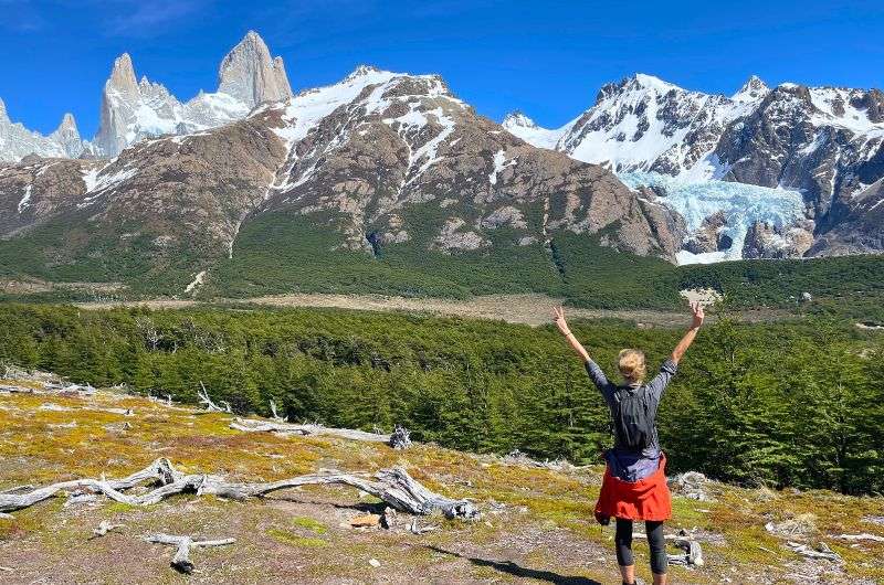
Hiking in Argentina is all about glaciers, mountains, lakes, and beautiful natural surroundings
Things I wish I’d known before going hiking in Argentina:
- It’s quite easy to hike in Argentina—they have the infrastructure for it.
- You don’t need a car in El Calafate and El Chaltén.
- Forget being able to scale Aconcagua if you’re not a serious expeditionist.
- You’re going to need to fly between places. Argentina is big. Really big—the eighth biggest in the world, in fact (about 1/3 the size of the US).
And now we're going to go over all these hikes together
FAQ 1: What is the best time of year to hike in Argentina?
The best time to hike in Argentina is during spring and summer, which is from October to April. This is when you’ll get the most reliable weather, especially in Patagonia, where winter (May to September) can be rough with snow and wind. If you're hiking in northern regions like Mendoza or Salta, you can hike year-round, but avoid the scorching summer months of December to February if you're not a fan of heat. For most hikers, late spring (October, November) and early fall (March, April) are the sweet spots for perfect hiking conditions.
FAQ 2: What is the hiking capital of Argentina?
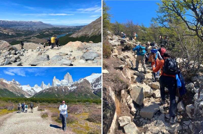
El Chaltén proudly holds the title of Argentina’s hiking capital. Nestled in southern Patagonia, it’s a small town but offers some of the best trails, like Laguna de los Tres and Laguna Torre, which provide killer views of Mount Fitz Roy. The entire town seems like it was built specifically for people who want to lace up their boots and hit the trails (and, unfortunately, they don’t even change when heading to the restaurants!). If hiking is your thing, El Chaltén is where you want to be.
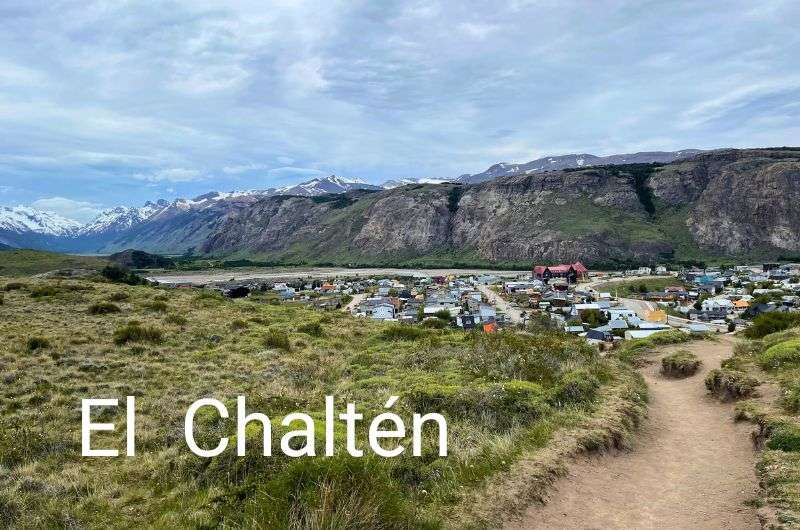
El Chaltén
Itinerary tip: We spent a week just in the El Chaltén area, hiking up and down and all around, but also kayaking at Perito Moreno! Get my 7-day El Chaltén itinerary.
FAQ 3: Is hiking in Patagonia hard?
Hiking in Patagonia can be hard, but it depends on the trail. Patagonia is famous for its rugged terrain and unpredictable weather, so some hikes, like the Vinciguerra Glacier trail or Laguna de los Tres, can be challenging with steep climbs and rough paths. That said, there are plenty of moderate and even easy hikes too. So, no, you don’t need to be a mountaineer, but being prepared for a workout (and some crazy wind) is a good idea.
Pro tip: Patagonia isn’t just Argentina, it’s Chile, too! Chile even slightly beat out Argentina in the number of trails on my list of top hikes in Patagonia (all-day-long hikes, too!), and Torres del Paine is one of its crown jewels, offering some of the most stunning multi-day treks on the continent." Give it a gander if Patagonia is on your radar.
FAQ 4: Does Argentina have good hiking?
Yes, Argentina has incredible hiking! I’ve hiked enough day-long trails around the world to be an expert. I’ve said it before and I’ll say it again: From the rugged peaks of Patagonia to the subtropical jungles around Iguazú Falls, there’s a mind-blowing variety of landscapes that make hiking in Argentina so amazing. I stick to day hikes, and Argentina is ideal for this style of trekking—you get jaw-dropping views without needing to commit to multi-day adventures.
Sometimes, all you need to do is take the first step... I've filtered out the best hotels in Argentina for you
Save it for yourself to come back to later, or share with your friends on social media!
Find more travel content, photos, and fun on:
Whether you want an easy stroll or a challenging climb, Argentina’s trails deliver. Here is a smorgasbord of Argentina’s day hikes that have left a lasting impression on me:
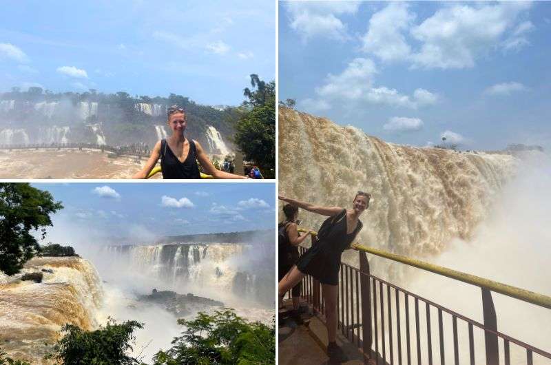
1. Iguazú Falls hikes (Misiones): Several trails, easy to moderate, 5 hours total
Iguazu Falls
Hike length: 15 km (9.2 mi) in total
Elevation gain: 108 m (354 ft)
Difficulty level: Easy to moderate
Hiking time: 5 hours in total
Trailhead: Google Maps link to trailhead
Hotel recommendation: Loi Suites Iguazú Hotel
As much of a spectacle as the Brazilian side of Iguazú Falls is, it’d only be fair to visit the Argentine side as well. You seriously can't see too much of these natural wonders! Argentina offers a wider array of hiking trails for you to choose from and this is one of the most popular, for good reason. Hiking this way around Iguazú Falls allows you to get up even closer for a completely distinct experience from that on the Brazilian side.
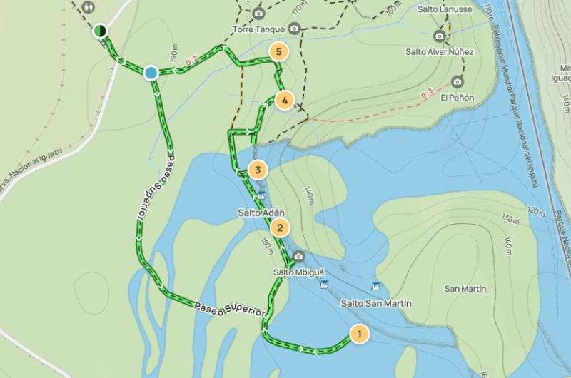
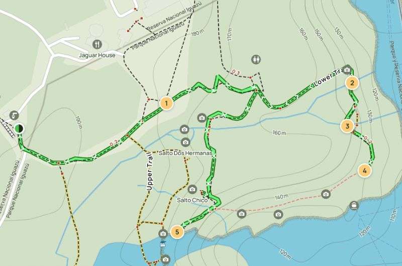
This longer hike comprises four separate trails, all but one of which start from Estación Cataratas:
- Upper Circuit
- Lower Circuit
- Macuco Trail
- Devil’s Throat
You have to get up early and be incredibly fit to do it. Or else, just pick one or two trails to get through—they’re all pretty breathtaking.
Top tip:
- To hike on the Argentine side of Iguazú Falls, you have to buy your ticket online in advance. The price is ARS 20,000 (USD 24), and you'll need to choose a specific time due to the bus schedule. I highly recommend getting there right at opening time (8 am) to visit the most popular spots before other tourists come flocking.
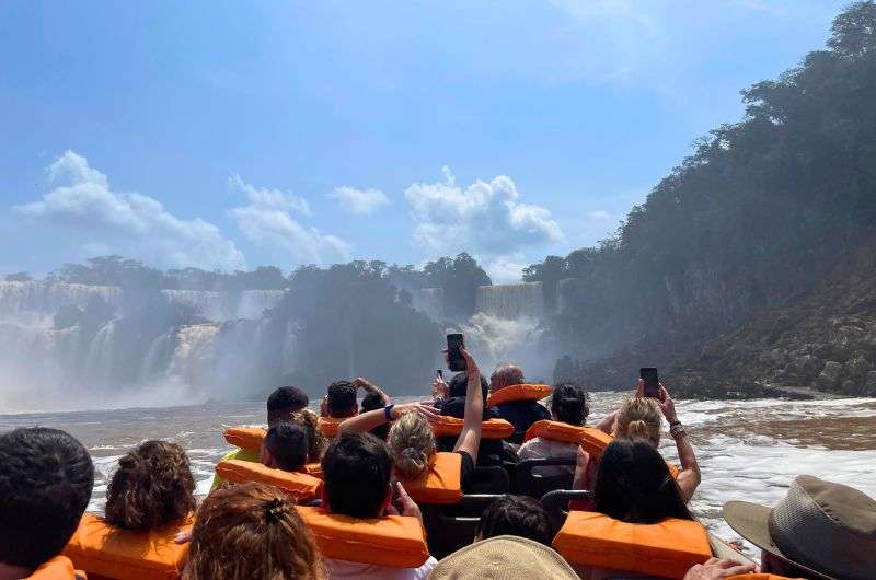
We took a boat tour on the Brazilian side of Iguazu Falls and got up very close to the water (read: we were drenched!)
In addition to the hiking trails, you can get a boat tour that takes you right up to the waterfalls. We’d already taken a boat tour on the Brazilian side, so we didn’t bother doing it again.
Itinerary tip: I’ve described the perfect way to spend 3 days at the Iguazú Falls + practical planning tips in my Iguazú Falls Guide and 3-day itinerary.
Upper Circuit, Iguazú Falls
Opt for this route to get an ethereal sense of floating above the falls (map on Alltrails)
You’ll kick off your adventure with the first of the Iguazú Falls trails, the Upper Circuit, at Estación Cataratas. This is where you should get on the Rainforest Ecological Train, your leisurely chariot. It's free to ride and goes at a not-so-speedy 20 km/h (14 mi/h), so sit back, relax, and take in the lush and leafy vibes for a short while.
The trail unfolds on a metal path, offering a breezy walkway dotted with benches. Good luck claiming one, though—they're like hotcakes, soon snapped up by anyone but you. As you meander, there are six lookout points where you can pause and be taken aback by the spectacular views of the falls. Trust me, you're getting up close and personal with the cascades here. You're practically walking on them—it’s the closest I’ve ever gotten to feeling like Jesus.
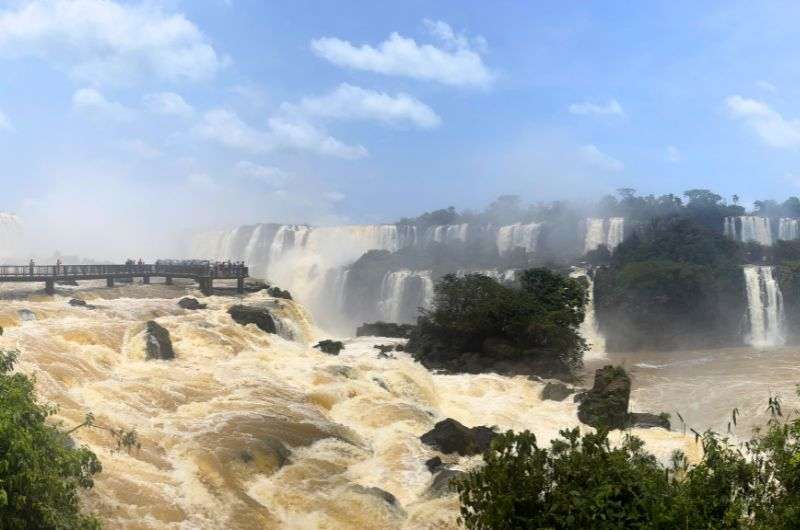
THIS is how close you get to Iguazu Falls on the Upper Circuit
Lower Circuit, Iguazú Falls
Map of the Iguazú Falls Lower Circuit. See route details on Alltrails
The Lower Circuit starts at the same point as the Upper Circuit does. It's a tad longer, but if I had to pick one, I'd definitely recommend the lower one. Why? It gives you those killer panoramic views. When you're beneath the waterfalls, they seem even more gargantuan than from above.
And just like before, you're walking on metal walkways 90% of the time, making the trek pretty easy. Just a heads-up: it's noticeably hotter here than on the Upper Circuit.
Macuco Trail, Iguazú Falls
The trek also kicks off at Estación Central, and guess what? You're hopping on that Rainforest Ecological Train again. This hike isn't your typical half-hour stroll. The terrain's a bit more challenging, but if you're itching to trace the fauna's footsteps and really soak in the wilderness, you’ll love it for sure. The trail carves its way through the lush forests of the jungle, so you’ll certainly spot some of the endemic critters in the wilderness. We saw a bunch of monkeys (okay, maybe five), butterflies, lizards, and ants. The latter might sound a bit boring, but those ants were seriously massive!
The Macuco Trail isn’t as popular as the other two trails, which is great, because that means way fewer people. As a sweet bonus, at the end of the trail, you'll be treated to a view of Salto Arrechea—a waterfall with a natural pond.
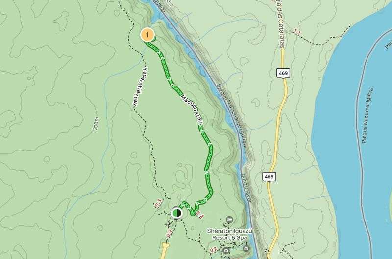
Map of Iguazú Falls’ Macuco Trail. See route details on Alltrails
Devil’s Throat, Iguazú Falls
The Devil's Throat is one of the most popular hikes on the Argentine side of Iguazú Falls. Unfortunately, the trail was closed when we were there, and it looks like it’ll remain closed throughout 2024. A massive rise in water levels has significantly damaged the walkways that lead to the viewpoint. So yeah, sad times, but at least you heard it here first(!)
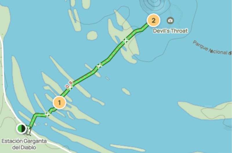
Map of Iguazú Falls’ Devil’s Thorat approach. See route details on Alltrails
2. Perito Moreno glacier walk, a UNESCO World Heritage Site (Los Glaciares National Park): Moderate, 1.5 hours
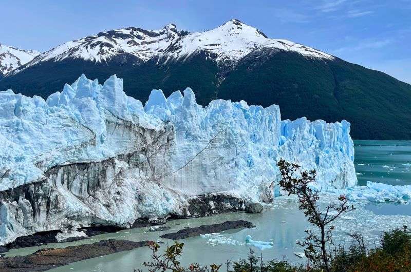
Perito Moreno with its fantastic blues
Hike length: 4.7 km (2.9 mi), out and back
Elevation gain: 180 m (590 ft)
Difficulty level: Moderate
Hiking time: 1.5 hours
Trailhead: Google Maps link to trailhead
The Perito Moreno trail is in Los Glaciares National Park and taking the tour costs ARS 12,000 (USD 13.8) per person. Park your car in the parking lot, where there’s a well-equipped visitor center from which to get all the essential information and a map of the area. Then, you have two options: take a free bus to the glacier or hoof it. Yes, the correct answer is the latter.
The best trails are the blue one and the red one. After a short walk, you’ll soon be trying to spot the falling ice that crashes into the water with a mighty boom. For once, we got lucky and caught it. It was how I imagine an exploding bomb sounds—it's absolutely deafening, and if you weren’t cold already, you’d feel a chill down your spine.
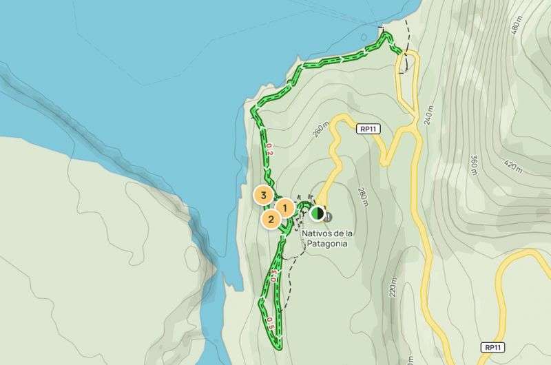
Map of the Perito Moreno glacier tour (see it in full on Alltrails)
I noticed that the national park's roads are excellently managed—nice, smooth asphalt; and no potholes. While the trail’s elevation profile and distance might seem tame, don’t be fooled. You’re walking to a glacier, and this means only one thing: it’s cold, even in summer, and so there's always a risk that you’ll slip on the icy ground. But the whole path is made of steel and is excellently constructed, so overall, I highly recommend walking. I chose to walk and was rewarded with stunning views, and I found it was quieter because most (ahem, lazy) people opt for the bus.
Once you get to the glacier, you can take a boat, though I don’t recommend this option; it seems pointless to me as better views are had on the walk-up. The perspective I got from the path is quite fun—the boats look tiny compared to the glacier’s enormity.
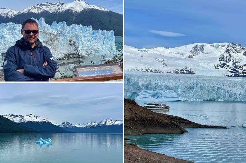
Perito Moreno
It’s amazing how blue the glacier is, besides being enormous. The surrounding mountains rise to 3,000 m (9,840 ft), and the glacier itself stands 50 m (165 ft) above the water level. I was also captivated by how flat and yet beautifully cracked the glacier wall is. I just wanted to touch it!
Tip: It's very windy here, don’t underestimate it, so no matter which month you visit, bring suitable clothing.
Read more: I have an entire 7-day itinerary for El Chaltén and Los Glaciares National Park, including logistics and my favorite activities. Check it out!
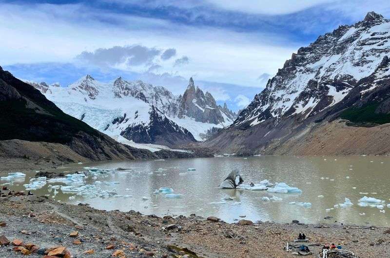
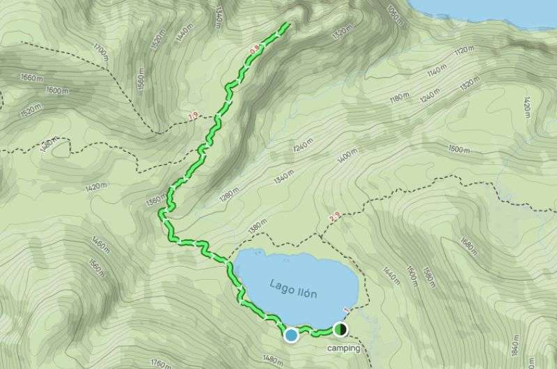
3. Laguna Torre, El Chaltén hike (Los Glaciares National Park): Moderate, 5 hours
Laguna Torre
Hike length: 17.5 km (10.9 mi), out and back
Elevation gain: 501 m (1,643 ft)
Difficulty level: Moderate
Hiking time: 5 hours
Trailhead: Google Maps link to trailhead
Hotel recommendation: Destino Sur Hotel & Spa de Montaña
This trail starts right in El Chaltén, which is super convenient—no need for any driving. I've marked the official trailhead above, which is pretty much where I kicked off my hike. But hey, if you want to cut through a field in El Chaltén and join up with the trail later, knock yourself out.
The trail is marked well and the terrain isn't too challenging. The main reason this hike is rated “moderate” is that it involves trekking a full 17.5 km (10.9 mi), so it's long, but not particularly tough.
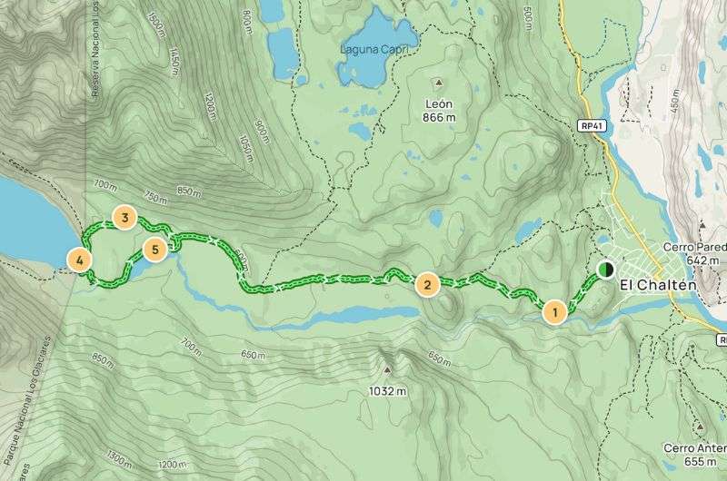
Map of the Laguna Torre, El Chaltén hike (see details of the hike on Alltrails)
It’ll take you through the valley of the Río Fitz Roy. The first 2 km (1.2 mi) is a steady ascent until you reach Mirador Margarita. From here, the views are stunning, especially of Cerro Torre and the Margarita waterfall. Beyond that, the path isn’t too demanding, but do expect some climbs until you reach Laguna Torre.
The trail is variable enough to stay interesting, but it never gets too exciting, if you know what I mean. It consists of several easy-to-follow paths, and some rockier areas, and if it’s been raining, you’ll run into some large muddy puddles. Nothing serious, though, and you’ll be fine even just in sneakers. At Laguna Torre, the mountain vistas range from “OMG, wow!” to “Aw man, the clouds are covering everything,” with the Southern Patagonian Ice Field stretching out in the distance when visibility is good.
If the mountains are shrouded in clouds, it might just not be your day, but I recommend trying to wait it out. Clouds are known to clear away sometimes, y’know, and because it gets windy on the Laguna Torre trail, chances are at any point, it’s only a matter of time before they do. When we visited, a lot of people turned back too soon having given up all hope of seeing anything, surrendering to their assumed bad luck. (Old men literally shouting at clouds.) But not us, oh no. We waited and were rewarded with some fantastic views of the peaks.
Tip: Don’t be tempted to turn back without reaching the viewpoint at the end. You may feel like you’ve seen it all before you get there, but you’d be very wrong. Make the loop counterclockwise to get the most out of the views. Beware of the loose rocks on the last part of the walk, so focus on those ankles and watch your step.
Be careful not to twist your ankle on the rocky trail!
Another tip: This is one of the more popular routes, so if you're not a fan of crowded trails, I’d suggest heading out early in the morning. Any later you might inadvertently set off with a group, and it can be tough to shake them off unless you sprint ahead or take an early break.
For all you crazy camping kids, you can camp by the lake. The campsite is just off the trail—it’s hard to miss. Right, this is all the backpacking advice you’ll get from me.
If you’re more like I am (sensible, and love the comfort of a hotel bed), I recommend the Destino Sur Hotel & Spa de Montaña. The rooms are lovely, all brand new. Honestly, what I remember most is sinking into that soft mattress and getting an exceptionally good night’s sleep after doing the Laguna Torre hike. That was all I needed.
Tip: If you’re planning to continue your hiking adventures in Patagonia, I highly recommend crossing the border to Chile and exploring hikes in Torres del Paine, another must-see for hiking enthusiasts.
4. Los Horcones hike (Mendoza): Moderate, 1.5 hours
Los Horcones Hike
Hike length: 6.1 km (3.79 mi), out and back
Elevation gain: 141 m (463 ft)
Difficulty level: Moderate
Hiking time: 1.5 hours
Trailhead: Google Maps link to trailhead
This one’s a moderate challenge, beginning exactly where many serious climbers begin their route to Aconcagua, the highest summit in the Americas. Even though I’m not brave (or mad) enough to take on Aconcagua in its entirety, I am proud to be able to say I’ve completed a three-kilometer hike somewhere around its foot.
Of course, if you’re more hardcore than I am, by all means, go further. Just bear in mind that you won’t physically be able to scale Aconcagua without serious preparation; meanwhile, most people could hike this portion of the trail without any equipment whatsoever.
Map of the Los Horcones hike (see map on Alltrails)
Mendoza is the nearest cluster of actual civilization to the trailhead, nearly three hours’ drive away. I recommend you stay here, and although there is a parking lot at the trailhead, you’ll need to pay for it in Mendoza, before you even set off. Ask your hotel reception for help with this.
Because it’s a popular route, the Los Horcones hike is well signposted and you’ll encounter several other people along the way, all of whom will seem to be in a buoyant, almost triumphant mood for having made it to one of the most extreme points in the world. Don’t get me wrong—it’s nice to be in a happy, like-minded company.
In the summer, the landscape along your hike will be a hazy mix of arid rocks and dusty green flora against a backdrop of cloudless blue sky. It's simply beautiful, provided you’re lucky with the weather, of course. But in the winter?... Let's not go there, literally.


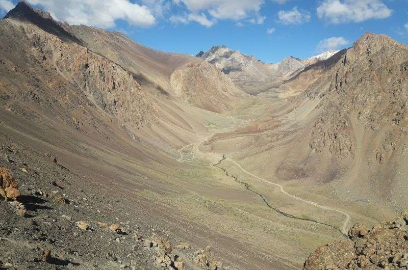
5. Vinciguerra Glacier trail (Tierra del Fuego): Hard, 4.5 hours
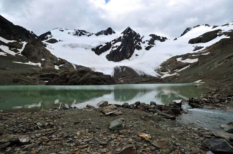
Vinciguerra Glacier
Hike length: 11.6 km (7.21 mi), out and back
Elevation gain: 675 m (2,215 ft)
Difficulty level: Hard
Hiking time: 4.5 hours
Trailhead: Google Maps link to trailhead
This trail is more out of the way (and that’s saying something for Argentina), just north of the city of Ushuaia in the southernmost province of Tierra del Fuego. The journey to the bottom of the earth is certainly worth it for the amazing views, not just from this hike itself, but of the city’s entire surroundings. And who wouldn’t jump at the chance to touch a glacier?... Okay, some people, sure. But I trust you’re quite the outdoorsy type if you’re on this page.
However, the Vinciguerra Glacier trail isn’t for the unfit or ill-equipped. If you’re neither of these things, keep reading about this incredible half-day trail.
The walk affords some unique and beautiful natural landscapes from start to finish, all year round, but fall and winter are obviously the seasons when you’re going to get the iciest conditions. This is both a blessing because the ice and snow make everything more spectacular; and a curse, because this trail is already on the muddy side, and the worse weather conditions mean more mud. Be prepared for slippery terrain by packing some tundra-appropriate footwear, even crampons to be safe.
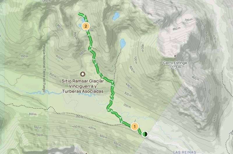
Map of the Vinciguerra Glacier trail (full hike details on Alltrails)
It begins with a steep hike through dense forest, and there’s an even steeper climb at the end up to the lagoon. You might need some proper poles (no, not your pals Andrzej and Mariusz) in addition to the crampons to get you up there. If you then circle the lagoon, you’ll soon reach the glacier... and touch it! Another goal achieved; now to get even muddier on the way down.
Is Ushuaia worth visiting?
Although it’s hard to get to, Ushuaia is worth visiting if you’re into stunning natural landscapes. It’s known as “the end of the world" because it's the southernmost city on earth. Moreover, it’s a gateway to some truly off-grid adventures: hiking up snowy mountains, visiting penguin colonies, and even embarking on cruises to Antarctica (though they’re really expensive, as you might guess). The city itself has a cozy, frontier vibe with decent local food and museums. One thing that could put anyone off, though, is the weather: it’s damp and dreary and the average temperature rarely makes double digits.
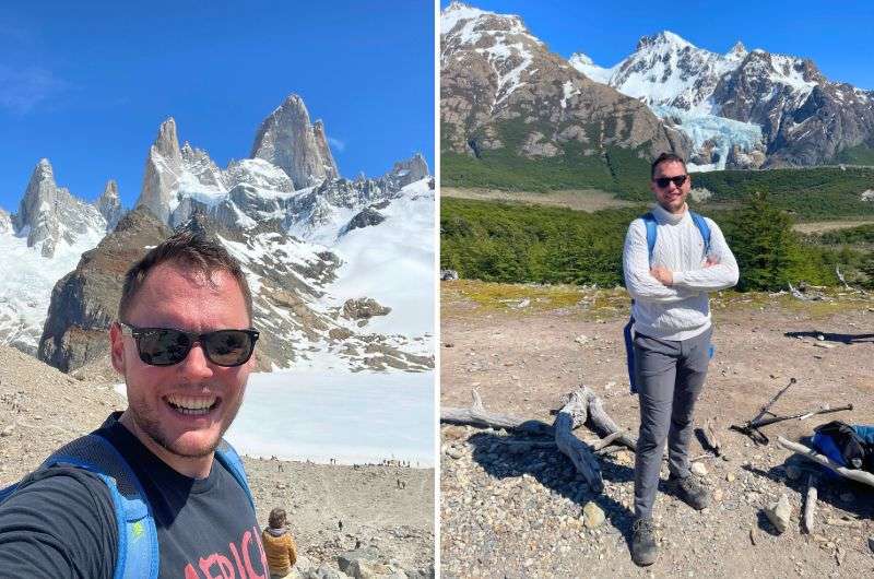
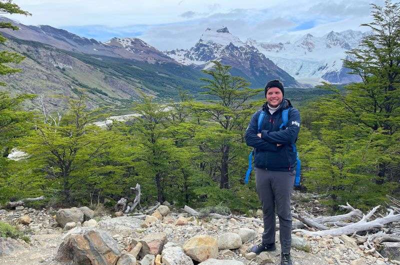
6. Laguna de los Tres, El Chaltén hike (Los Glaciares National Park): Hard, 8 hours
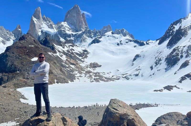
Me, conquering the Laguna de los Tres hike
Hike length: 21.9 km (13.6 mi), out and back
Elevation gain: 1,000 m (3,280 ft)
Difficulty level: Hard
Hiking time: 8 hours
Trailhead: Google Maps link to trailhead
Hotel recommendation: Destino Sur Hotel & Spa de Montaña
If you haven’t gushed over how incredibly lucky you are to be able to see Los Glaciares National Park’s scenery with your own eyes, you will today. You’ll tackle the legendary Laguna de los Tres hike, one of the absolute best hikes in El Chaltén—I think so, the world thinks so, and now you will too.
This trail offers some of the most spectacular panoramic vistas in all of Patagonia, including the iconic Mount Fitz Roy that’ll be in front of you for the entire first half of the hike (because then you turn back and go the same way you got there). It’s a challenging yet incredibly rewarding hike that will leave you in awe of nature.
Tip: If this trail intrigues you, head over to my full guide on the Laguna de Los Tres Hike.
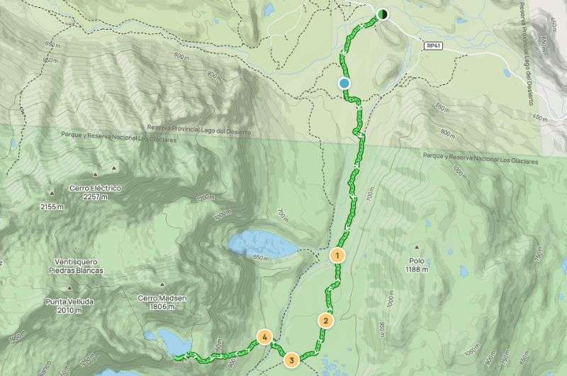
Map of the Laguna de los Tres hike (see the map on Alltrails)
Before we start, let me just say: that El Pilar Valley (which is the one you’ll be walking through) is perhaps the most beautiful sight I’ve ever seen. It's a wide valley with a river, surrounded by enormous, glacier-covered mountains. If you’re lucky, you might even hear the thunderous sound of falling ice. It’s also possible to reach Laguna de los Tres from the El Chaltén side, but the El Pilar Valley is a place you simply cannot miss.
I prefer starting on this side also because it gives you a much gentler and more photogenic end to the trek. In contrast, starting from El Chaltén involves a fairly steep descent at the end. And last but not least, starting from El Pilar, you'll encounter very few people compared to starting at El Chaltén, and the views are significantly better, in my opinion.
My top tips for the Laguna de los Tres hike:
- Start from the top: Start your hike on the El Pilar side, not in El Chaltén. The trek is much better, with better views, and it’s less crowded on this side.
- Drinkable water: The water around this area is drinkable, so make sure to bring a refillable bottle. It’s not just one laguna! Keep your eyes peeled and your camera ready before reaching the end of this hike, because Laguna Piedras Blancas is there to steal a substantial chunk of your attention.
- Must-visit add-on: And don’t stop right when you reach Laguna de los Tres, either—take a detour to the viewpoint over Laguna Sucia. It's about 500 m (0.3 mi) along the lake to the left. The views there are dramatically more stunning!
Get ready for beautiful views that you won't be able to stop taking pictures of...
Again, it’s important to remember that Patagonian weather is a fickle beast. Then head to the trailhead… which one? The one that matches the hike by name is on Google Maps as Sendero Laguna De Los Tres, the other is just a little closer to El Chaltén and is the El Pilar trail. It doesn’t matter which you choose because they converge after the initial section.
Start early, ideally before 9 am, to avoid the crowds and increase your chances of calm, wind-free conditions at the lagoon. The trail is well-marked, much like in the USA, so you can’t really get lost. Argentina did a great job on this!
Starting from El Pilar, you'll encounter very few people compared to El Chaltén, and the views are significantly better. The auto strikes again! I highly recommend hiking from El Pilar and back. It's a much gentler and more photogenic end to the trek. In contrast, starting from El Chaltén involves quite a steep descent at the end.
The first part of the hike involves a steady ascent. For the first 3.5 km (2.1 mi), you’ll gain about 300 meters in elevation. The climb is a bit of a workout, but the dramatic views make it worth every step. Think of it as entering Middle Earth, with ice, snow, and towering 3,000 m (9,800 ft) walls surrounding you.
After the initial climb, the trail levels out and you’ll pass by smaller, cascading waterfalls and lakes. Notably, you’ll pass by Laguna Piedras Blancas, a stunning lake with crystal-clear, icy blue waters with the imposing Fitz Roy in the background. You’ll want to have your camera out for these views!
Almost there! Start early to beat the crowds, or at least try to
About 5 km in, you’ll reach a fork. Go left to continue towards Laguna de los Tres.
Talk about the calm before the storm; the middle section is the flat before death. The last part tested our physical fitness and agility on unstable terrain. There was a steep, rocky climb waiting for us. We met an older couple on the trail who had to turn back during the last section because they just didn’t have the energy left.
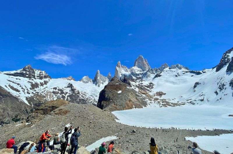
But once we got up there, we got to take in the sight of Laguna de los Tres, nestled at the base of Mount Fitz Roy. The laguna is often dotted with icebergs, adding to the beautiful scenery. To me, it looked like something of a fairy tale, and I half expected an evil queen to send a hero to rescue a princess from its icy depths. It’s that magical!
Now just eat your lunch and watch the view
Take your time to soak in the views. If you’re lucky and start early, you might experience the rare calm without the typical Patagonian winds. Have your packed lunch by the laguna, snap a ton of photos, and just bask in the magnificence of it all. Since it’s an out-and-back trail, remember that every step you take up, you’ll have to take down. I found the descent through the last passage tougher than the climb.
If you can handle some more dramatic views, I strongly recommend you take a 500 m (0.3 mi) detour to the Mirador Laguna Sucia, a viewpoint that gives you a peak at the next lagoon. The views there are dramatically more stunning!
Tip for the mighty: if 22 km isn’t enough for you and you’d love not to have to walk back the same way, there is a trail from Laguna de los Tres all the back to El Chaltén. Check Alltrails for details on this route.

7. Los 14 Colores del Hornocal viewpoint trail (Jujuy): Moderate, 1 hour
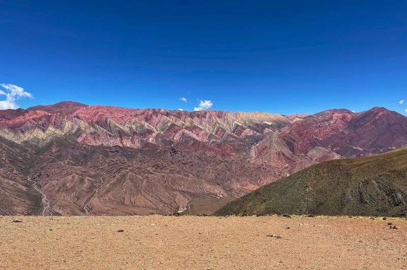
Can you find all the 14 colors?
Hike length: 1.4 km (13.60.9 mi), out and back
Elevation gain: 102 m (335 ft)
Difficulty level: Moderate
Hiking time: 45 minutes to 1 hour
Trailhead: Google Maps link to trailhead
Hotel recommendation: Hotel Altos de la Viña
The 14-Color Mountains of Hornocal are located near the small town of Humahuaca, home to about 11,300 people. This town isn't exactly a knockout, but there are a few sights to see. And a big plus, unlike some other places in this area, is that the people here are really friendly.
The drive to the trailhead of the 14-Color Mountains viewpoint hike is along a rocky road, so get your back and butt ready for the drive out there. Then, more rocks! And despite what you might picture when you hear the word “hike”, you won’t be going uphill on this one. At least, not on the way there...
It’ll take you 45 minutes to an hour to go there and back, including time for photos at the two viewpoints. You'll start by descending from an altitude of 4,350 m (14,272 ft), where you'll get a stunning view of this remarkable colorful mountain straight from the parking lot.
It reminds me of Rainbow Mountain in Peru, but it’s much bigger. However, that altitude... it was a bit of a problem for me. You think “Oh, just 700 m each way?! Easy peasy!”, but nope. The altitude makes it feel much longer, especially as you make your way back up.
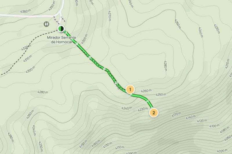
You start up top and make your way down to the Los 14 Colores del Hornocal viewpoints—it's a short hike, but the altitude is a killer! Full map and details on Alltrails
At the viewpoint, there's no wind, and apart from other cars at the top and tourists throughout, nothing will disturb you. If you'd like to walk around and challenge yourself at this altitude, there are several other hiking options. The trails are beautiful, and most are up to 1 km (0.6 mi) long. I definitely recommend choosing one in advance, as not every kilometer is created equal.
On some trails, you might walk a kilometer while also climbing over 700 m (2,300 ft) in elevation—an absolute killer. In all honesty, you may just figure that you don’t have enough oxygen to do any serious hiking, and be happy that you not only get 2 viewpoints at the bottom, but can also count the parking lot as a third and call it a day.
What else can you see in Humahuaca? Besides loads of tourists, you might catch the oldest building in the region, a church, and the Cabildo, close to the town square. From the square, you can climb up to the Monument to the Heroes of Independence.
8. Valle Encantado trail (Salta): Moderate, 2 hours
Can you see the colored Cerro Tintin mountain in the back?
Hike length: 8 km (4.97 mi), out and back
Elevation gain: 210 m (689 ft)
Difficulty level: Moderate
Hiking time: 2 hours
Trailhead: Google Maps link to trailhead
Hotel recommendation: MG Design Hotel Boutique
Los Cardones National Park spans 650 km² (250 mi²), offering everything you’d expect to find in the Argentine wilderness, from mountains and valleys to gorges and cacti. The park's elevation ranges from 2,700 to 5,070 m (8,860 to 16,630 ft). Some good news: you can drive into the park with ease.
You might not be visiting this national park for hiking per se. After all, its prime attraction is its prehistoric fossils (it even boasts dinosaur tracks!), so this is just a short recommendation. At the same time, you never know when the urge to hike will strike.
Map of the Valle Encantado trail. See map on Alltrails
When we went, naturally, this urge did strike. We chose the longest trail—Valle Encantado, or “Enchanted Valley". It took us about three hours, and I do recommend it. "Hike" might be a bit of an overstatement in my opinion; it’s more a leisurely stroll with stunning views. For instance, you'll see the beautifully-colored Cerro Tintin mountain with its sediment layers that perfectly complement the already picturesque desert. We happened to be the only ones on the trail, not counting some 100 bird species. Bring your binoculars.
9. Salinas Grandes “trail” (Salta): Easy, 1 hour (mostly a drive)
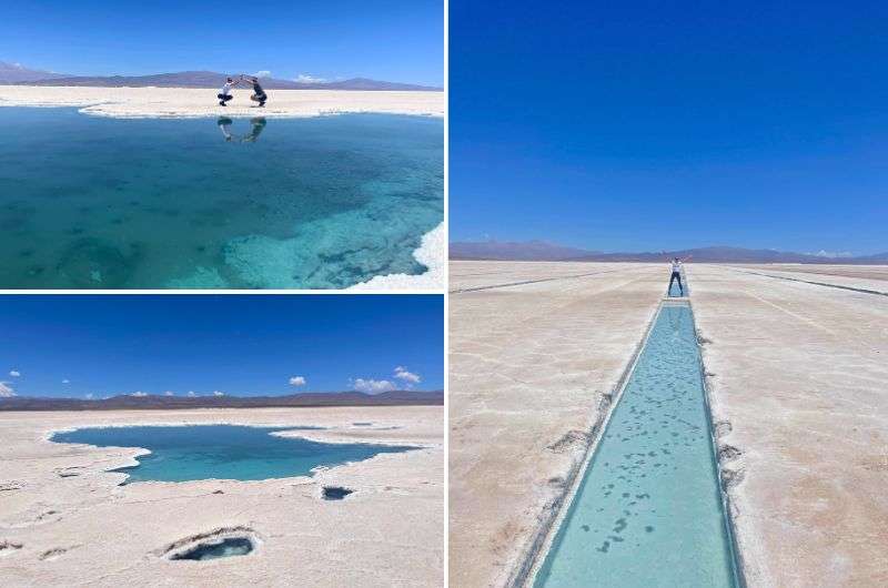
Salinas Grandes—the salt desert
This one is unique because it isn’t a hike at all, but it’s just so special that I had to include it in the list: The Salinas Grandes are Argentina's most famous salt flats, covering a whopping 6,000 km² (about 2,300 square mi), and ancient Incan trails once crossed this stunning land, making it a significant trade route in pre-Columbian times. That's a lot of ground, but they're still playing second fiddle to Bolivia's Salar de Uyuni, which stretches over 10,582 km² (about 4,086 square mi). Still, the scope of this place is impressive, known as “the white desert".
You can spend anywhere from 30 minutes to three hours at Salinas Grandes—not sure what people do there for over an hour though. I assume they’re simply on a mission to make their Instagram followers envious with arty photos of the many salt pools. Here, salt crystallizes directly from the water, much like in the Dead Sea. It's a fascinating process, and if you're lucky, you might catch sight of some locals harvesting the salt.
But I know why you’re here, dear reader—you want to hike, not splash around. Well, you can’t. There is a very short walk that you can take right at the information center, and yes, even then the surroundings make you feel like you’re on another planet. The sky above this never-ending white blanket is a particularly intense shade of blue.
If you want to go further into the flats, you’ll need to hire a guide and drive in. We chose the self-drive option, meaning we stayed in our own car while our guide zipped in front of us on his scooter. He’ll take you to some spots where you can get out and walk around. Along the way, you’ll come across salt pools which are bizarre and beautiful, and VERY salty. Tip: don’t touch your eyes after you touch the water! Take it from me—my eyes were puffed up for the rest of the day.
There’s also an occasional glimpse of the surrounding mountains, a reminder that you’re still very high up. All of this made me feel like a small speck of existence. I’m the first to admit: that I’m pretty dense when it comes to religious concepts, but this is what I imagine Christian fundamentalists mean when they talk about heaven.
The real showstopper, though, is the flat, mirror-like surface of the salt flats when the ground reflects the sky after rainfall. Unfortunately, I didn’t catch it after rain, but even on a dry day, I can’t explain enough how surreal the Salinas Grandes is—the real thing is far superior to the photos.
You can be really creative when it comes to photos in Salinas Grandes. The amount of people trying (and failing) to get a good shot is hilarious
This isn’t your typical hike; it’s neither long nor strenuous, and there’s almost no incline to it. To me, it was a meditative walk in one of the most unique landscapes I’ve ever seen.
This is a must-do if you make it to Salta—take a look at my complete guide to planning your Salinas Grandes trip if you want to experience it for yourself. I talk about everything from getting there to getting a guide (because you’re not allowed in without one), and when to visit to get the perfect mirror-like effect.
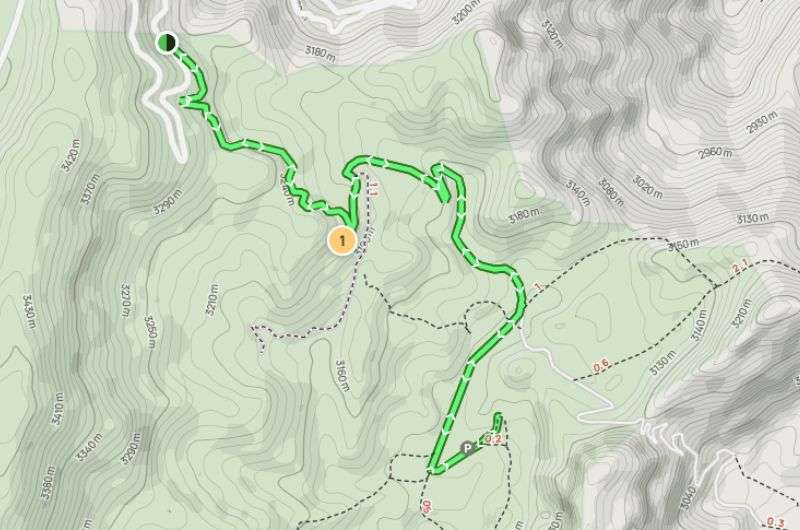
10. Quebradas de las Señoritas hikes (Jujuy): Moderate, 2 hours
Quebrada de las Señoritas
Hike length: 4.8 km (2.98 mi), out and back
Elevation gain: 320m (1050 ft)
Difficulty level: Moderate
Hiking time: 2 hours
Trailhead: Google Maps link to trailhead
Hotel recommendation: Hotel Altos de la Viña
Quebradas de las Señoritas is a huge desert area with red rocks, sitting at an altitude of 2,900 m (9,500 ft), so to those that tend to suffer from altitude sickness: you're in the clear here.
You can drive right up to the start of Quebradas de las Señoritas, which is open daily from 08:30 am to 6 pm. Continue until you hit the staffed parking area, park your vehicle, and head to the entrance gate. You'll need to pay for a guide; they won't let you through to the hiking trails without one.
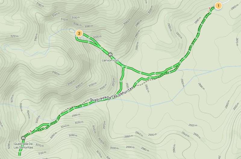
Map of the Quebradas de las Señoritas hikes (map from Alltrails)
There are two hikes to choose from: a three-hour one and a one-and-a-half-hour one. We (two people) opted for the shorter one at ARS 3200 (USD 4). The guided tours usually form groups of around six people.
It's typically hot here most of the year, so like us, you'll probably appreciate the option of a shorter trek. It's still absolutely beautiful and worth it. If you want to communicate at least a bit with the guide, you’d better download an offline dictionary as the phone signal is unreliable. Luckily, I know some Spanish, so we managed to communicate somewhat, but don't expect to get by with English here.
11. Doctor’s Viewpoint, Bariloche hike (Río Negro): Moderate, 2.5 hours
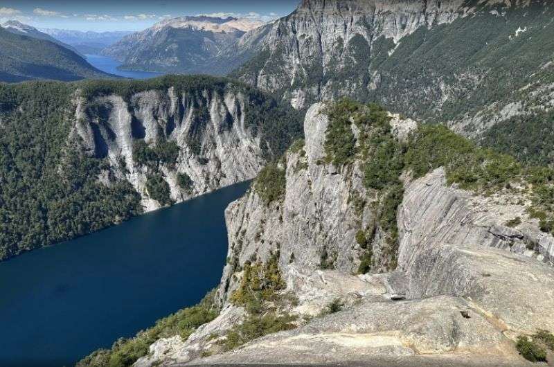
Find other great pictures of the Doctor’s viewpoint on alltrails.com
Hike length: 8.5 km (5.28 mi), out and back
Elevation gain: 337 m (1,105 ft)
Difficulty level: Moderate
Hiking time: 2.5 hours
Trailhead: Google Maps link to trailhead
If you find yourself in Bariloche in Nahuel Huapi National Park (Argentina’s oldest and perhaps prettiest national park), spare some time to take the trail up to the Doctor’s Viewpoint. But who is this doctor, anyway? That'd be local physician, Dr. Jakob, who used to sit in this very spot, admiring the view of the mountains and nearby Lake Fray. You’d have thought he’d have more pressing matters to attend to, really.
Map of the route Dr. Jakob took when he slacked off his day job (see map details on Alltrails)
Hiking to the Doctor’s Viewpoint is supposedly like stepping into a postcard. Start early in the morning, just as the mist clears and the sun begins to peek over the mountains. They say the trail itself isn’t too tough, but there are some steeper bits, enough to get your blood pumping.
The path winds through dense forests, and every now and then, there’s a break in the trees where you can get a look at the vast blue waters of Lake Nahuel Huapi down below.
The trail itself is well marked, and fairly popular yet not too crowded. This is probably due to its remote location—it’s a long-ass drive to the nearest town. I didn’t get the chance to take this hike because it was too out in the sticks for the time that I had, but from what I’ve heard from fellow Argentinophiles, I missed out big-time.
When they reached the viewpoint, they were floored. The panorama from the top is unreal—you get snow-capped peaks stretching into the distance as well as the sparkling lakes below on all sides. You can even see parts of Bariloche nestled against the shore.
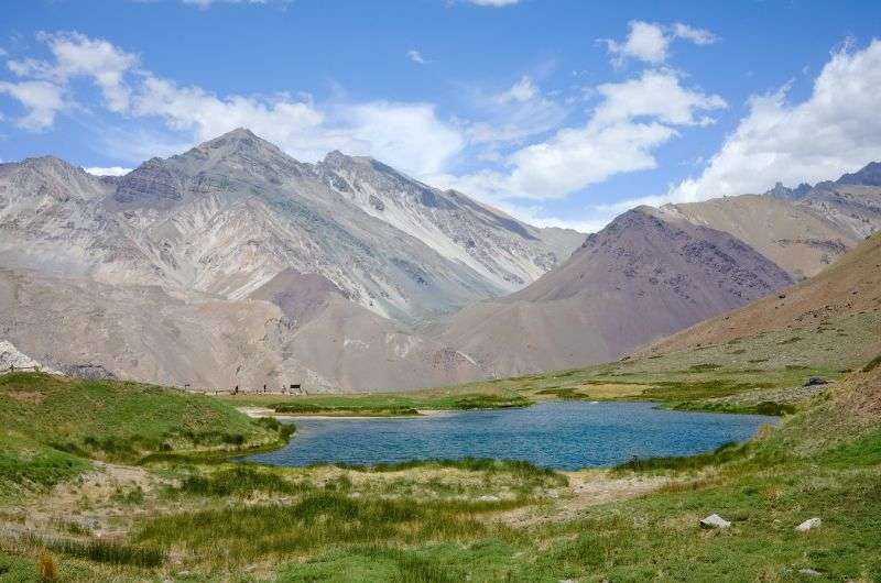
12. Cerro Negro hike (Mendoza): Hard, 4 hours
Cerro Negro
Hike length: 8 km (4.97 mi), out and back
Elevation gain: 741 m (2431 ft)
Difficulty level: Hard
Hiking time: 4 hours
Trailhead: Google Maps link to trailhead
Last but certainly not least, it’s the hike to the peak of Cerro Negro. Compared to how remote some other entries on this list are, it’s a real breeze to get to this trailhead—it’s practically a stone’s throw away from Mendoza City. You’ve got no excuse.
First things first: parking. As you drive away from Mendoza to the southwest, you want to find a plot of land called La Crucecita. It’s a place of farmhouses, hostels, campsites, and horses; and this is where you’ll park. It costs ARS 500 per person (about USD 2.50), which goes toward the maintenance of the trail.
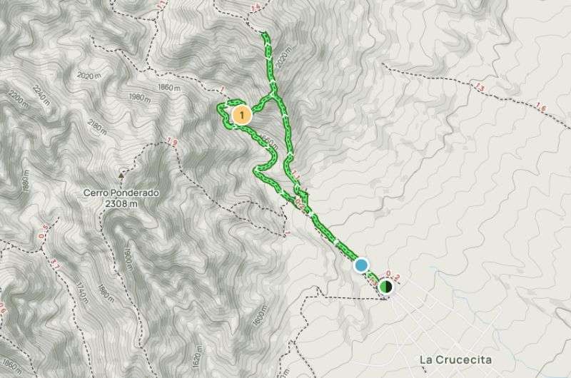
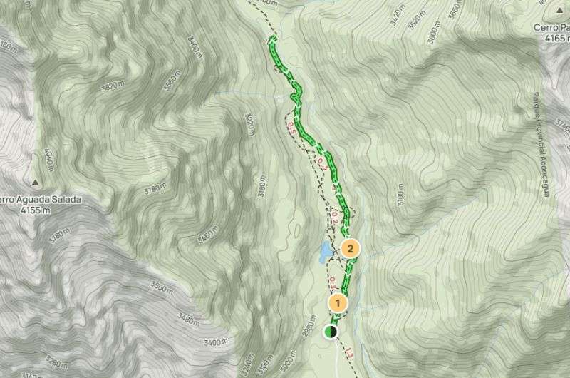
Map of the Cerro Negro hike
The hike kicks off with a steady incline, and right away, you're surrounded by mountains (shocker). The trail is a mix of rugged, rocky paths and desert-like brush, with cacti and thorny plants all around. The air was so clear, I could see for miles even early on in the hike. You can tell the area doesn’t get much rain; the environment is noticeably dry and arid.
As I got higher, the trail got a bit steeper, but nothing too crazy—it’s more of a long, gradual ascent. Every now and then, I'd pause to catch my breath and take in the views. The contrast of the blue sky against the brown and red hues of the mountains was cool (but not as unreal as the 14-Color Mountains in Jujuy, which is the entry on this list that the Cerro Negro hike is the most comparable to in terms of terrain).
I didn’t see many other hikers, but I did see some horseback riders, presumably on horses borrowed from the aforementioned farm at La Crucecita. I can understand why someone might want to do this trail on horseback—get another creature to do all the work—but I’m not the equestrian type, personally. Besides, I came prepared with my walking poles.
At the top of Cerro Negro, the view is pretty impressive. You can see the entire Mendoza valley, vineyards stretching out like a green patchwork quilt below the towering peaks. It was a relatively challenging hike, but was it worth it? Yes, absolutely, especially considering how close it is to the city.
Top day hikes in Argentina, done!
Well, these were my favorite hikes from Argentina. From trekking across glaciers to navigating rugged mountain passes, each trail offers something unique. You're welcome!
Sometimes, all you need to do is take the first step... I've filtered out the best hotels in Argentina for you
Save it for yourself to come back to later, or share with your friends on social media!
Find more travel content, photos, and fun on:
This post contains affiliate links. I earn a small commission if you make bookings through my links, at no additional cost to you. Thank you for your support!
Comments | Thoughts? Give us a shout!
Recommended articles
Los Glaciares National Park is a hiker's paradise and giving it anything less than 7 days is bonkers. This spot needs to be at the top of your bucket list.
In this article, I'll touch upon everything from the blue dollar market, ordering the right type of coffee, staying safe, and how to recognize if you’re getting flipped off, Argentina style.
Patagonia is one of the most beautiful places in the world. I have seen plenty of incredible destinations on this Earth, but once you’ve visited Patagonia, it’s like you’re a different person. On my list, you'll find a total of 15 hikes, with 9 in Chile and 6 in Argentina.
About me
Hi, I’m Jan. I travel fast and intensely, whether I’m exploring the buzz of Tokyo in 3 days or road-tripping through mountains and beaches on a 3-week Thailand adventure. And no matter where I am, you’ll always find me in a comfortable hotel at night and eating the best food.
If that sounds like your kind of journey, hop on board, and let’s explore the world together!
I started this blog after realizing how tough it can be to find reliable, authentic travel info. You wouldn’t believe how many “travel bloggers” never even visit the places they write about! On Next Level of Travel, you can count on my full honesty and insights drawn from my firsthand experiences.
More about meHere’s the deal: not every destination is all superlatives and unicorns. I’ll let you know if a tourist attraction isn’t worth your time, like skipping overrated stops in my 2-week Spain itinerary. And when I find something truly special—like the perfect mix of culture and nature in Cape Town—you can trust that it’s worth adding to your itinerary.
Next Level of Travel s.r.o.
ID: CZ07036612
Adress: Voctářova 2449/5, Praha, Czech Republic
Created by myTimi